Interactive Network Map
Where the plan would connect
Planning phase. An independent plan; nothing is funded or built yet. What this means
Illustrative only — not engineered alignments, sites or tracks
Use two fingers to move or zoom the map, or the + / − buttons. Zoom in to see station names; tap a number for details.
Basemap and existing layers: Overture Maps Foundation 2026-09-23.1 (© OpenStreetMap contributors, ODbL; land cover © ESA WorldCover, CC BY 4.0) and USGS 3DEP terrain. Existing transit is a schematic based on LANTA public information — see lantabus.com for official routes. Proposed lines connect destinations for illustration only; measured distances follow existing streets.
Phase 2: corridor options past Bethlehem
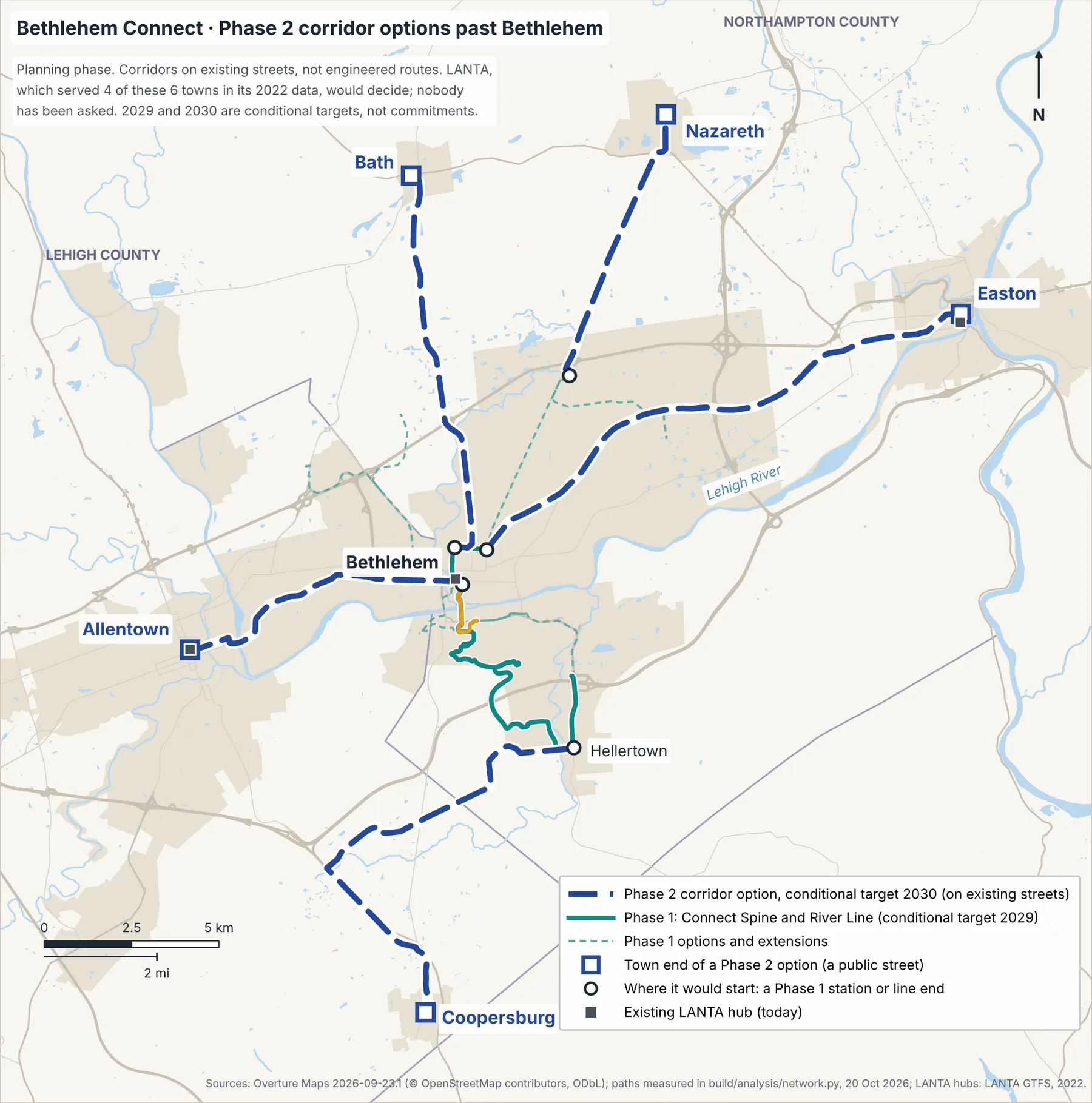
Measured on existing streets; in-vehicle minutes in the kinematic model, without intermediate stops.
- Corridor
- Allentown
- From
- Downtown / Broad Street
- km
- 8.98
- min (model)
- 17.5
- Corridor
- Easton
- From
- North Bethlehem
- km
- 16.00
- min (model)
- 30.6
- Corridor
- Nazareth
- From
- Bethlehem Square / US 22
- km
- 8.37
- min (model)
- 16.4
- Corridor
- Bath
- From
- Moravian University
- km
- 11.69
- min (model)
- 22.6
- Corridor
- Saucon Valley south and Coopersburg (PA 309)
- From
- Hellertown / Saucon Valley
- km
- 14.49
- min (model)
- 28.5
LANTA's buses already reach most of these towns (2022 data)
In LANTA's 2022 data, its buses stopped within 400 m of the town ends in Allentown, Easton, Nazareth and Saucon Valley south, but no stop was within 5 km of Bath or Coopersburg (current service to confirm). A Connect Phase 2 corridor would be coordinated with LANTA, which decides, and would not simply run beside its buses. LANTA has agreed to nothing, and the plan's records show no request to LANTA about Phase 2. Measurements, existing routes and caveats are on Corridors & Stops.
How to read this map
Points are station areas, not sites
Lines are illustrative
The Airport Link is drawn on its own
Park extensions and stop options are options on options
Existing layers are context
Long-term rail ideas are text only
All destinations (text list)
- #
- 1
- Destination
- I-78 Park & Ride (Hellertown P&R)
- Status
- Phase 1 · conditional target 2029
- Elevation (m)
- 84
- #
- 2
- Destination
- Hellertown / Saucon Valley (Main St)
- Status
- Phase 1 · conditional target 2029
- Elevation (m)
- 87
- #
- 3
- Destination
- Goodman Campus / Stabler Arena
- Status
- Phase 1 · conditional target 2029
- Elevation (m)
- 96
- #
- 4
- Destination
- Mountaintop / Iacocca Hall
- Status
- Phase 1 · conditional target 2029
- Elevation (m)
- 275
- #
- 5
- Destination
- Lehigh University Center / Asa Packer Campus
- Status
- Phase 1 · conditional target 2029
- Elevation (m)
- 123
- #
- 6
- Destination
- Farrington Square
- Status
- Phase 1 · conditional target 2029
- Elevation (m)
- 83
- Details
- View Farrington Square
- #
- 7
- Destination
- Third Street / SteelStacks
- Status
- Phase 1 · conditional target 2029
- Elevation (m)
- 72
- #
- 8
- Destination
- Downtown Bethlehem / Broad Street
- Status
- Phase 1 · conditional target 2029
- Elevation (m)
- 104
- #
- 9
- Destination
- Moravian University
- Status
- Phase 1 · conditional target 2029
- Elevation (m)
- 94
- Details
- View Moravian University
- #
- 10
- Destination
- North Bethlehem (Linden & Elizabeth)
- Status
- Phase 1 · conditional target 2029
- Elevation (m)
- 103
- #
- SL
- Destination
- St. Luke's University Hospital (Fountain Hill)
- Status
- Phase 1 option · conditional target 2029Evaluated destination · its branch is a Phase 1 option
- Elevation (m)
- 101
- #
- WC
- Destination
- Wind Creek
- Status
- Phase 1 · if demand supports itEvaluated destination · extension only if demand (Phase 1)
- Elevation (m)
- 79
- Details
- View Wind Creek
- #
- NX
- Destination
- North expansion — Bethlehem Square / US 22
- Status
- Phase 1 · if demand supports itEvaluated destination · extension only if demand (Phase 1)
- Elevation (m)
- 112
- #
- MH
- Destination
- LVH–Muhlenberg (Schoenersville Rd)
- Status
- Phase 1 option · conditional target 2029Airport Link stop option
- Elevation (m)
- 109
- #
- AP
- Destination
- ABE airport passenger terminal
- Status
- Phase 1 option · conditional target 2029Airport Link stop option
- Elevation (m)
- 112
- #
- 4W
- Destination
- 4th & Wyandotte
- Status
- Phase 1 option · conditional target 2029Candidate stop on St. Luke's branch option A
- Elevation (m)
- 84
- Details
- View 4th & Wyandotte
- #
- HT
- Destination
- Hanover Township (Northampton County) Municipal Park — Jacksonville Rd
- Status
- Phase 1 · if demand supports itExtension only if demand · extends the Airport Link
- Elevation (m)
- 106
- #
- BT
- Destination
- Bethlehem Township Municipal Park — Farmersville Rd at Walter Rd
- Status
- Phase 1 · if demand supports itExtension only if demand · extends the North expansion to Bethlehem Square
- Elevation (m)
- 108
- #
- SB
- Destination
- South Bethlehem (City parkland) — PA 412 at Commerce Center Blvd
- Status
- Optional · only if a separately proposed park is builtA stop option on the Valley Express (a Phase 1 option); no target year
- Elevation (m)
- 72
- #
- P2
- Destination
- Allentown Transportation Center (N 6th St)
- Status
- Phase 2 · conditional target 2030Town end of the Allentown corridor option (regional map above)
- Elevation (m)
- 102
- #
- P2
- Destination
- Easton Centre Square (Northampton St)
- Status
- Phase 2 · conditional target 2030Town end of the Easton corridor option (regional map above)
- Elevation (m)
- 64
- #
- P2
- Destination
- Nazareth borough center (Broad St & Center St)
- Status
- Phase 2 · conditional target 2030Town end of the Nazareth corridor option (regional map above)
- Elevation (m)
- 158
- #
- P2
- Destination
- Bath borough center (Main St & Northampton St)
- Status
- Phase 2 · conditional target 2030Town end of the Bath corridor option (regional map above)
- Elevation (m)
- 133
- #
- P2
- Destination
- Saucon Valley south (at LANTA's 2022 stops at the corridor's end)
- Status
- Phase 2 · conditional target 2030Town end of the Saucon Valley south and Coopersburg (PA 309) corridor option (regional map above)
- Elevation (m)
- 127
- #
- P2
- Destination
- Coopersburg borough center (Main St & State St)
- Status
- Phase 2 · conditional target 2030Town end of the Saucon Valley south and Coopersburg (PA 309) corridor option (regional map above)
- Elevation (m)
- 146