Long-Term Vision
Built to expand — without promising what doesn't exist yet
Planning phase. An independent plan; nothing is funded or built yet. What this means
Illustrative horizons, each step gated
By 2029–2030 — Phase 1, then Phase 2 (conditional)
2031–2035 — complete the network
2035–2045 — regional and rail
2045+ — beyond Bethlehem (speculative)
Prepared for the long term: ten design rules
- 1Put the corridor on the map nowPennsylvania's Municipalities Planning Code lets a town's official map show transit rights-of-way; when an owner applies to develop mapped land, the town gets a year to negotiate. It buys time, not land.
- 2Keep old rail corridors wholeFederal railbanking lets an unused rail line become a trail and still be restored to rail later — only when a railroad files to abandon a line and agrees.
- 3Buy land early only through the proper federal path49 U.S.C. 5323(q) lets FTA help buy right-of-way before environmental review is done; nothing can be built until review is complete.
- 4Reserve width for the final number of tracks, build two firstOregon's safety rules require at least 15 ft (4.57 m) between main tracks (Illinois sets the same between main and side tracks); high-speed rail design uses 16.5 ft. A railroad sharing the line may require more.
- 5Build platforms for the longest future trainDallas (DART) lengthened platforms at 28 light-rail stations to 450 ft for 3-car trains, at about $129M. Lengthening later is expensive.
- 6Get express service from passing points firstCaltrain's passing tracks at two locations let Baby Bullet expresses run San Francisco–San Jose in ~57 min vs. ~90 min for locals.
- 7Add BRT passing lanes when bus volumes call for themThe BRT Standard is reported to give full credit without station passing lanes below about 20 buses an hour (a third-party reproduction of the scorecard; to confirm with ITDP), counting every bus that uses the station.
- 8Publish open data from day one, accessibility includedGTFS-Realtime best practice: refresh at least every 30 s. GTFS records whether each stop and trip is wheelchair accessible — a rider needs both.
- 9Feed the network that exists; stay flexible on regional railLANTA EBS already runs every 15 minutes between Allentown and Bethlehem. The regional rail study has not picked a route.
- 10Follow the federal steps and test ridership honestlyIndiana's Double Track NWI changed federal programs after ridership fell, then won its grant agreement in January 2021.
Sources: PA Municipalities Planning Code Art. IV (official map; statute text to confirm); 16 U.S.C. 1247(d) and Surface Transportation Board rules (railbanking); 49 U.S.C. 5323(q); Oregon OAR 741-315-0010 and Illinois 92 IAC 1500.120 (track centers); California HSR TM 1.1.21; DART platform extension program; Caltrain; ITDP BRT Planning Guide and BRT Standard (2024); GTFS-Realtime best practices; LVPC rail study (2024) and Phase II. Retrieved 18 Oct 2026.
Service tiers that can grow
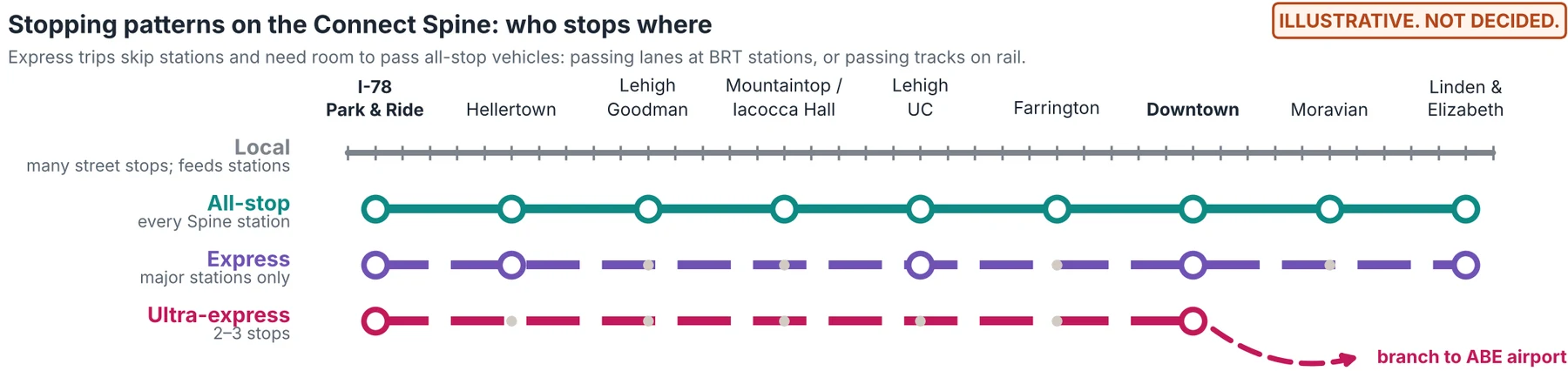
1 · Local Exists (LANTA)
2 · Connect all-stop Phase 1 · conditional target 2029
3 · Express Long-term idea
4 · Ultra-express Speculative vision
Lesson from SEPTA
How long-term routes with multiple tracks get planned
Step 1
Shape the vision in public
Share the plan and gather input; a formal corridor study starts once a sponsoring agency exists.
Step 2
Protect the land
Official maps in each town on the route; railbanking only if an abandonment comes up; early purchase only through 5323(q).
Step 3
Get into the regional plan
Ask the Lehigh Valley Transportation Study to add the project to its fiscally constrained long-range plan.
Step 4
Enter FTA Project Development
Compare alternatives, choose a locally preferred alternative, adopt it into the long-range plan.
Step 5
Finish environmental review
A categorical exclusion, an Environmental Assessment with a finding of no significant impact, or a full Environmental Impact Statement.
Step 6
Take the right funding path
Small Starts is a likely fit for BRT (eligibility to confirm); New Starts or Core Capacity for later rail.
Step 7
Build in stages, reserve for the next
Two tracks or two BRT lanes first; room kept for passing tracks, passing lanes and longer platforms.
Step 8
Measure, then upgrade
Add express service and passing points when ridership and frequency justify them; re-check ridership before each step.
Track spacings below are state safety minimums for railroad workers, not passenger-rail design standards; the railroad that owns a shared line may require more, and curves need extra space.
- Configuration
- Single track + passing sidings
- Track centers
- 15 ft (4.57 m) at sidings
- Span between outer tracks
- 15 ft at sidings only
- Right-of-way (illustrative)
- not sourced
- Service it allows
- Trains meet at sidings; mostly local, express only with carefully timed meets
- Configuration
- Double track
- Track centers
- 15 ft (4.57 m) minimum; 16.5 ft (5.03 m) for high-speed rail
- Span between outer tracks
- 15 ft (4.57 m)
- Right-of-way (illustrative)
- ~50 ft usable in a ~100 ft corridor (one Bay Area example, to confirm)
- Service it allows
- One track each way, all-stop; express needs added passing tracks (e.g., Caltrain)
- Configuration
- Triple track
- Track centers
- 15 ft between each pair
- Span between outer tracks
- 30 ft (9.14 m)
- Right-of-way (illustrative)
- not sourced
- Service it allows
- A middle track lets peak-direction expresses pass locals
- Configuration
- Quad track
- Track centers
- 15 ft between each pair
- Span between outer tracks
- 45 ft (13.72 m)
- Right-of-way (illustrative)
- roughly 70–80 ft (arithmetic only, to confirm)
- Service it allows
- Two local + two express tracks: full express all day (e.g., New York's 1904 subway)
The bus version: passing lanes at stations
Our judgment
Trains both ways, stop spacing, vehicles and automation
Mode by segment, not everywhere
Both ways
Express and ultra express
Third Street and Farrington Square
A “hybrid electric train” would be battery-electric
Automation only where it is safe
Phase 1 buses: chargers at both ends are required
If batteries or chargers aren't ready
Estimates: build/analysis express_screening.py, rail_checks.py and vehicle_staff.py, from the repo's kinematic and energy models (re-run 21 Oct 2026). Precedents are leads from web search summaries retrieved 19 Oct 2026, and the primary pages are still to be read: battery trains in Schleswig-Holstein and Ortenau (railwaygazette.com, stadlerrail.com, news.siemens.co.uk, electrive.com); the Dallas streetcar (metro-magazine.com, bisnow.com); German hydrogen fleets (h2-view.com, rollingstockworld.com); automated buses, including CAVForth (sustainable-bus.com, route-one.net) and Jacksonville's NAVI (jaxtoday.org, hoodline.com); automated metros (uitp.org); LANTA's January 2026 fuel emergency (lantabus.com, wfmz.com). Naming a railroad, agency or product describes it only: none has been asked or has agreed to anything. The trigger test for any express bus is in the plan's internal notes and has not been reviewed by LANTA.
Easy to reach by train — rail-ready siting
3 proposed stops on the corridor
7 places a short walk away
Everything else: one Connect ride
The siting rule (proposal)
- Everything this plan proposes to build sits at a Bethlehem Connect stop, or within about a 10-minute walk of one.
- The biggest draws — SteelStacks and Third Street, the Dig & Discover gallery, Wind Creek and Farrington Square — cluster around the stops on the rail-ready corridor.
- Places on the hill connect by bus, not train. Mountaintop sits about 190 m above Farrington Square, too steep for a conventional train; the Spine reaches a rail-ready stop in about 9 minutes, and the gondola option would add a second way down.
- A future train stop would be added at an existing Connect station — sharing its platform area, shelter, bike parking, chargers and signs — not built as a separate building somewhere else.
- Keep the corridor clear: don't place new buildings on land the rail-ready corridor would need, and keep trails on former rail lines open.
Measured: proposed stations and evaluated destinations
Walking distances follow the Overture/OpenStreetMap pedestrian network at 80 m per minute (4.8 km/h), measured to proposed station points, not platforms. Ride times are Phase 1 estimates.
- I-78 Park & Ride
Already there — under a 2-minute walk → I-78 Park & Ride
On the rail-ready corridor - Hellertown / Saucon Valley
~5 min on Connect → I-78 Park & Ride
One Connect ride to a rail-ready stop - Goodman / Stabler Arena
~9 min on Connect → I-78 Park & Ride
One Connect ride to a rail-ready stop - Mountaintop / Iacocca Hall
~9 min on Connect → Farrington Square
One Connect ride to a rail-ready stop - Lehigh University Center
~11-minute walk (0.8 km) → Farrington Square
Short walk to a rail-ready stop - Farrington Square
Already there — under a 2-minute walk → Farrington Square
On the rail-ready corridor - Third St / SteelStacks
Already there — under a 2-minute walk → Third St / SteelStacks
On the rail-ready corridor - Downtown / Broad Street
~3 min on Connect → Farrington Square
One Connect ride to a rail-ready stop - Moravian University
~7 min on Connect → Farrington Square
One Connect ride to a rail-ready stop - North Bethlehem
~9 min on Connect → Farrington Square
One Connect ride to a rail-ready stop - St. Luke's (Fountain Hill)Evaluated destination
~4 min on Connect → Farrington Square
One Connect ride to a rail-ready stop - Wind CreekEvaluated destination
Already there — under a 2-minute walk → Wind Creek
On the rail-ready corridor - Bethlehem Square / US 22Evaluated destination
~20 min on Connect → Farrington Square
Longer trip (extension only)
- Place
- I-78 Park & Ride
- Nearest Connect stop
- At the stop
- Nearest rail-ready stop
- I-78 Park & Ride
- How you'd get there
- Already there — under a 2-minute walk
- Rating
- On the rail-ready corridor
- Nearest Connect stop
- At the stop
- Nearest rail-ready stop
- I-78 Park & Ride
- How you'd get there
- ~5 min on Connect
- Rating
- One Connect ride to a rail-ready stop
- Nearest Connect stop
- At the stop
- Nearest rail-ready stop
- I-78 Park & Ride
- How you'd get there
- ~9 min on Connect
- Rating
- One Connect ride to a rail-ready stop
- Nearest Connect stop
- At the stop
- Nearest rail-ready stop
- Farrington Square
- How you'd get there
- ~9 min on Connect
- Rating
- One Connect ride to a rail-ready stop
- Nearest Connect stop
- At the stop
- Nearest rail-ready stop
- Farrington Square
- How you'd get there
- ~11-minute walk (0.8 km)
- Rating
- Short walk to a rail-ready stop
- Place
- Farrington Square
- Nearest Connect stop
- At the stop
- Nearest rail-ready stop
- Farrington Square
- How you'd get there
- Already there — under a 2-minute walk
- Rating
- On the rail-ready corridor
- Nearest Connect stop
- At the stop
- Nearest rail-ready stop
- Third St / SteelStacks
- How you'd get there
- Already there — under a 2-minute walk
- Rating
- On the rail-ready corridor
- Nearest Connect stop
- At the stop
- Nearest rail-ready stop
- Farrington Square
- How you'd get there
- ~3 min on Connect
- Rating
- One Connect ride to a rail-ready stop
- Place
- Moravian University
- Nearest Connect stop
- At the stop
- Nearest rail-ready stop
- Farrington Square
- How you'd get there
- ~7 min on Connect
- Rating
- One Connect ride to a rail-ready stop
- Place
- North Bethlehem
- Nearest Connect stop
- At the stop
- Nearest rail-ready stop
- Farrington Square
- How you'd get there
- ~9 min on Connect
- Rating
- One Connect ride to a rail-ready stop
- Place
- St. Luke's (Fountain Hill)Evaluated destination
- Nearest Connect stop
- At the stop
- Nearest rail-ready stop
- Farrington Square
- How you'd get there
- ~4 min on Connect
- Rating
- One Connect ride to a rail-ready stop
- Place
- Wind CreekEvaluated destination
- Nearest Connect stop
- At the stop
- Nearest rail-ready stop
- Wind Creek
- How you'd get there
- Already there — under a 2-minute walk
- Rating
- On the rail-ready corridor
- Place
- Bethlehem Square / US 22Evaluated destination
- Nearest Connect stop
- At the stop
- Nearest rail-ready stop
- Farrington Square
- How you'd get there
- ~20 min on Connect
- Rating
- Longer trip (extension only)
Measured: places people would visit
Same method. Existing places are shown for context; listing them implies no partnership.
- Dig & Discover main gallery (street level at the Third Street / SteelStacks stop)Proposal
Already there — under a 2-minute walk → Third St / SteelStacks
On the rail-ready corridor - National Museum of Industrial History, 602 E. 2nd St (a natural partner to approach)Exists today
~6-minute walk (0.4 km) → Third St / SteelStacks
Short walk to a rail-ready stop - SteelStacks campus — Visitor Center, 711 E. 1st St (event days)Exists today
~9-minute walk (0.7 km) → Third St / SteelStacks
Short walk to a rail-ready stop - Geology pavilion idea at the Mountaintop / Iacocca Hall stop (proposal)ProposalNear the proposed Mountaintop Discovery Gardens, a separate garden idea, not sponsored or endorsed by Lehigh University
~9 min on Connect from Mountaintop / Iacocca Hall → Farrington Square
One Connect ride to a rail-ready stop - Bethlehem Commons — candidate sites near SteelStacks (separate project; none secured)ProposalFarthest of four candidate sites shown; the range is 0.5–0.6 km
~8-minute walk (0.6 km) → Third St / SteelStacks
Short walk to a rail-ready stop - Lehigh's Grace Hall and Taylor Gym (sports venues)Exists todayFarther of the two shown
~10-minute walk (0.8 km) → Third St / SteelStacks
Short walk to a rail-ready stop - Goodman Campus fields (sports venues)Exists today
~9 min on Connect from Goodman / Stabler Arena → I-78 Park & Ride
One Connect ride to a rail-ready stop - Yosko Park, Southside (city park)Exists today
~12-minute walk (1.0 km) → Third St / SteelStacks
Short walk to a rail-ready stop - Historic Union Station building, Union Station Plaza — now a St. Luke's health center (Overture places data; to confirm)Exists todayMeasured for reference — not proposed as a station; no trains stop here today
~11-minute walk (0.9 km) → Farrington Square
Short walk to a rail-ready stop - Lehigh Valley Hospital–Muhlenberg, 2545 Schoenersville RdExists todayNot on the Phase 1 core lines — the Airport Link option (a Phase 1 option, conditional target 2029) would stop on Schoenersville Rd at the hospital's middle driveway. The walk shown follows mapped walkways to the hospital's map point; open data has no paths across the campus, so it is much longer than the straight line, and the walk to an entrance is to confirm. A Muhlenberg branch from Moravian (~3.4 km on streets) is another idea to evaluate
~12 min on Connect from LVH–Muhlenberg (Airport Link stop option, Phase 1 option · conditional target 2029) → Farrington Square
Longer trip (Phase 1 option only) - St. Luke's Anderson Campus, 1872 St. Luke's BlvdExists todayNot served by the plan — 7–9 km from the nearest proposed stop; long-term only
Not served yet — nearest proposed stop is 7.5 km away → Farrington Square
Not served by the plan yet
- Nearest Connect stop
- At the stop
- Nearest rail-ready stop
- Third St / SteelStacks
- How you'd get there
- Already there — under a 2-minute walk
- Rating
- On the rail-ready corridor
- Place
- National Museum of Industrial History, 602 E. 2nd St (a natural partner to approach)Exists today
- Nearest Connect stop
- Third St / SteelStacks · ~6-min walk
- Nearest rail-ready stop
- Third St / SteelStacks
- How you'd get there
- ~6-minute walk (0.4 km)
- Rating
- Short walk to a rail-ready stop
- Place
- SteelStacks campus — Visitor Center, 711 E. 1st St (event days)Exists today
- Nearest Connect stop
- Third St / SteelStacks · ~9-min walk
- Nearest rail-ready stop
- Third St / SteelStacks
- How you'd get there
- ~9-minute walk (0.7 km)
- Rating
- Short walk to a rail-ready stop
- Place
- Geology pavilion idea at the Mountaintop / Iacocca Hall stop (proposal)ProposalNear the proposed Mountaintop Discovery Gardens, a separate garden idea, not sponsored or endorsed by Lehigh University
- Nearest Connect stop
- Mountaintop / Iacocca Hall · ~5-min walk on mapped paths (49 m in a straight line)
- Nearest rail-ready stop
- Farrington Square
- How you'd get there
- ~9 min on Connect from Mountaintop / Iacocca Hall
- Rating
- One Connect ride to a rail-ready stop
- Place
- Bethlehem Commons — candidate sites near SteelStacks (separate project; none secured)ProposalFarthest of four candidate sites shown; the range is 0.5–0.6 km
- Nearest Connect stop
- Third St / SteelStacks · ~8-min walk
- Nearest rail-ready stop
- Third St / SteelStacks
- How you'd get there
- ~8-minute walk (0.6 km)
- Rating
- Short walk to a rail-ready stop
- Place
- Lehigh's Grace Hall and Taylor Gym (sports venues)Exists todayFarther of the two shown
- Nearest Connect stop
- Lehigh University Center · ~5-min walk
- Nearest rail-ready stop
- Third St / SteelStacks
- How you'd get there
- ~10-minute walk (0.8 km)
- Rating
- Short walk to a rail-ready stop
- Place
- Goodman Campus fields (sports venues)Exists today
- Nearest Connect stop
- Goodman / Stabler Arena · ~4-min walk
- Nearest rail-ready stop
- I-78 Park & Ride
- How you'd get there
- ~9 min on Connect from Goodman / Stabler Arena
- Rating
- One Connect ride to a rail-ready stop
- Place
- Yosko Park, Southside (city park)Exists today
- Nearest Connect stop
- Third St / SteelStacks · ~12-min walk
- Nearest rail-ready stop
- Third St / SteelStacks
- How you'd get there
- ~12-minute walk (1.0 km)
- Rating
- Short walk to a rail-ready stop
- Place
- Historic Union Station building, Union Station Plaza — now a St. Luke's health center (Overture places data; to confirm)Exists todayMeasured for reference — not proposed as a station; no trains stop here today
- Nearest Connect stop
- Farrington Square · ~11-min walk
- Nearest rail-ready stop
- Farrington Square
- How you'd get there
- ~11-minute walk (0.9 km)
- Rating
- Short walk to a rail-ready stop
- Place
- Lehigh Valley Hospital–Muhlenberg, 2545 Schoenersville RdExists todayNot on the Phase 1 core lines — the Airport Link option (a Phase 1 option, conditional target 2029) would stop on Schoenersville Rd at the hospital's middle driveway. The walk shown follows mapped walkways to the hospital's map point; open data has no paths across the campus, so it is much longer than the straight line, and the walk to an entrance is to confirm. A Muhlenberg branch from Moravian (~3.4 km on streets) is another idea to evaluate
- Nearest Connect stop
- LVH–Muhlenberg (Airport Link stop option, Phase 1 option · conditional target 2029) · ~13-min walk on mapped paths (250 m in a straight line)
- Nearest rail-ready stop
- Farrington Square
- How you'd get there
- ~12 min on Connect from LVH–Muhlenberg (Airport Link stop option, Phase 1 option · conditional target 2029)
- Rating
- Longer trip (Phase 1 option only)
- Place
- St. Luke's Anderson Campus, 1872 St. Luke's BlvdExists todayNot served by the plan — 7–9 km from the nearest proposed stop; long-term only
- Nearest Connect stop
- Bethlehem Square / US 22 · ~94-min walk
- Nearest rail-ready stop
- Farrington Square
- How you'd get there
- Not served yet — nearest proposed stop is 7.5 km away
- Rating
- Not served by the plan yet
What this does not claim
Why this matters for the other projects
Method: shortest walking path on the Overture Maps 2026-09-23.1 pedestrian network (including © OpenStreetMap contributors, ODbL) from each place to the proposed station points; elevations from USGS 3DEP. The historic Union Station building is measured for reference only and is not proposed as a station. Rail study status: LVPC passenger rail study (2024) and Phase II, retrieved 18 Oct 2026.
Would a train be quicker than the bus?
Minutes in the vehicle; waiting is extra. Phase 1 bus and gondola: the published Phase 1 network. Rail ideas: the earlier screening, with no frequency or station-access time; deep tunnel stations would add several minutes. LANTA: scheduled 2022 summer weekday trips, not current service.
- Trip
- Hellertown → Downtown
- Phase 1 bus
- 24.2
- Gondola option
- —
- Valley light rail idea
- 15.8
- Tunnel ideas (C / D)
- 7.9 / 8.2
- LANTA 2022 timetable (not current)
- 21.0 min; about every 60 min (Route 105)
- Trip
- Goodman → Downtown
- Phase 1 bus
- 19.6
- Gondola option
- —
- Valley light rail idea
- 18.8
- Tunnel ideas (C / D)
- 5.4 / 6.2
- LANTA 2022 timetable (not current)
- No 2022 LANTA stop near Goodman or Mountaintop (Lehigh's shuttles serve the campuses)
- Trip
- Mountaintop / Iacocca Hall → University Center
- Phase 1 bus
- 6.2
- Gondola option
- 6.0
- Valley light rail idea
- —
- Tunnel ideas (C / D)
- —
- LANTA 2022 timetable (not current)
- No 2022 LANTA stop near Goodman or Mountaintop (Lehigh's shuttles serve the campuses)
- Trip
- Farrington Square → Third Street / SteelStacks
- Phase 1 bus
- 1.6
- Gondola option
- —
- Valley light rail idea
- 1.8
- Tunnel ideas (C / D)
- 1.8 / 1.1
- LANTA 2022 timetable (not current)
- 1.0 min; about every 9 min (Routes 100, 103, 605)
- Trip
- Downtown → North Bethlehem
- Phase 1 bus
- 5.7
- Gondola option
- —
- Valley light rail idea
- 5.3
- Tunnel ideas (C / D)
- 5.3 / 3.1
- LANTA 2022 timetable (not current)
- 3.0 min; about every 60 min (Route 220)
The route, not the rails
Waiting matters most
What a train would not do
Method: build/analysis/trip_compare.py (21 Oct 2026). Phase 1 bus and gondola minutes from network.json; rail ideas from od_times.json (kinematic screening model). LANTA: its June–Sept 2022 GTFS feed (Wednesday 22 June 2022), direct or one-transfer trips between stops within 400 m of the same station points; LANTA has changed service since 2022. Average wait is taken as half the time between departures. The full table, with walking times, is in the plan's internal notes.
Connecting town to town, city to city, park to park
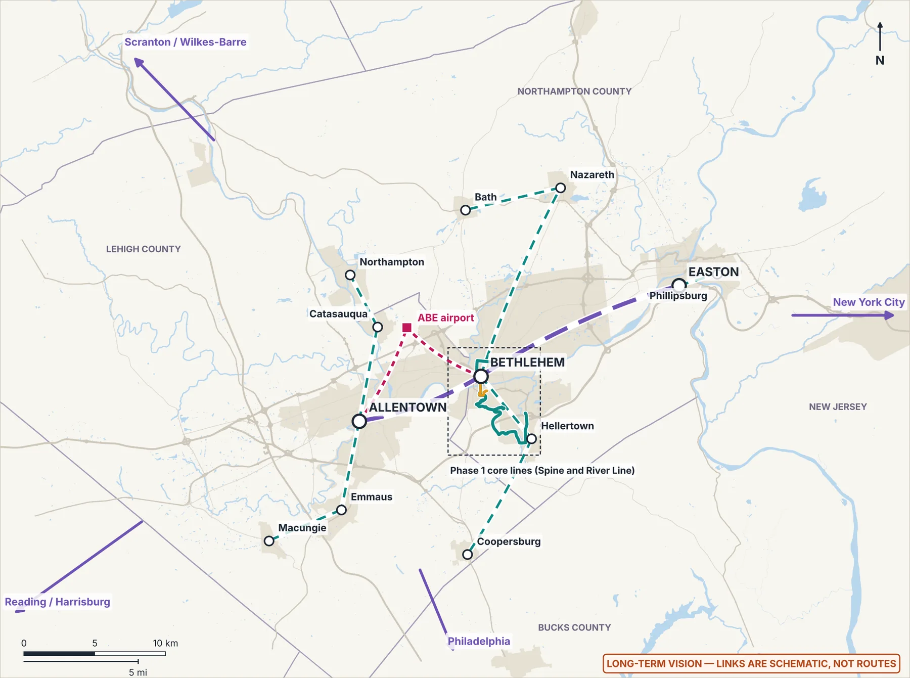
Town to town, inside the Lehigh Valley
- Pair
- Allentown ↔ Bethlehem
- Today
- LANTA EBS Green and Blue lines together run about every 15 minutes (since June 2023)
- Long-term idea
- River Line upgrade; Phase 2 Allentown corridor option (Downtown – Allentown Transportation Center), only if LANTA agrees; later, valley rail if justified
- Status today
- Operating (bus)
- Status of the idea
- ProposalPhase 2 · conditional target 2030
- Pair
- Bethlehem ↔ Easton
- Today
- EBS Blue Line runs Easton–Allentown–Bethlehem–Trexlertown
- Long-term idea
- Phase 2 Easton corridor option (North Bethlehem – Easton Centre Square, on Easton Ave and William Penn Hwy), only if LANTA agrees; later an express tier; park link to Hugh Moore Park
- Status today
- Operating (bus)
- Status of the idea
- Phase 2 · conditional target 2030Long-term idea
- Pair
- South Bethlehem ↔ Hellertown
- Today
- LANTA local bus; a ~1.2 mi trail gap between the South Bethlehem Greenway and the Saucon Rail Trail
- Long-term idea
- Connect Spine with a Hellertown trailhead stop
- Status today
- Operating (bus)
- Status of the idea
- Phase 1 · conditional target 2029
- Pair
- Hellertown ↔ Coopersburg
- Today
- Saucon Rail Trail, about 7.5 mi
- Long-term idea
- Park link stop at the Hellertown trailhead; the Phase 2 corridor option via Saucon Valley south, on PA 309
- Status today
- Operating (trail)
- Status of the idea
- ProposalPhase 2 · conditional target 2030
- Pair
- Bethlehem ↔ ABE airport
- Today
- LANTA serves ABE (current routes to confirm); intercity buses to Newark Airport leave from ABE
- Long-term idea
- First, better information on LANTA's and Trans-Bridge's existing ABE service; then the Airport Link bus option via LVH–Muhlenberg (7.99 km, ~13.5 min, model); later, an ultra-express Downtown ↔ ABE timed to existing intercity buses
- Status today
- Operating (bus)
- Status of the idea
- Phase 1 option · conditional target 2029Speculative vision
City to city
- City
- New York City
- Today
- Intercity bus
- Status (as of October 2026)
- Rail studied (2024): ~2 h 20 min–2.5 h estimated. No route picked, no funding; the regional Phase II study was funded in December 2025 (lead); no result found as of 19 Oct 2026.
- City
- Philadelphia
- Today
- Intercity buses; bus to Doylestown with a SEPTA rail transfer
- Status (as of October 2026)
- Rail studied (2024): ~1 h 46 min–1 h 52 min estimated; one of the Phase II study's candidates.
- City
- Reading
- Today
- No direct rail
- Status (as of October 2026)
- Allentown–Reading studied (~46 min, 2024); no service or funding.
- City
- Scranton / Wilkes-Barre
- Today
- No Lehigh Valley rail; the D&L Trail north is not yet continuous
- Status (as of October 2026)
- Scranton–New York rail plans bypass the Lehigh Valley.
- City
- Harrisburg
- Today
- No rail from the Lehigh Valley
- Status (as of October 2026)
- Not among the corridors studied.
The 2024 regional rail study looked at five corridors, all on Norfolk Southern freight lines, with estimated capital of $450M–$739M and 10–12 years to complete. Bethlehem Connect keeps a rail-ready valley corridor as a hedge, not a commitment.
Park to park — the “Park Link” idea Proposal
Transit stops at trailheads plus seasonal weekend shuttles from Connect or EBS stops. Each park manager would have to agree; none has.
- Park or trail
- Saucon Rail Trail
- Manager
- Saucon Rail Trail Oversight Commission
- Park Link idea
- Spine stop at the Hellertown trailhead
- Park or trail
- South Bethlehem Greenway
- Manager
- City of Bethlehem
- Park Link idea
- Stops at Lehigh and the Southside; trail loop once the gap closes
- Park or trail
- Saucon Park
- Manager
- City of Bethlehem
- Park Link idea
- Weekend stop on the Spine
- Park or trail
- Monocacy Way
- Manager
- City of Bethlehem
- Park Link idea
- Moravian / Downtown stop
- Park or trail
- Sand Island & D&L Trail
- Manager
- City of Bethlehem; D&L National Heritage Corridor
- Park Link idea
- River Line / Third St stop, paired with the proposed Bethlehem Commons
- Park or trail
- Hugh Moore Park (Easton)
- Manager
- City of Easton
- Park Link idea
- Seasonal shuttle from the Valley Express or EBS Blue Line
- Park or trail
- Lehigh Parkway (Allentown)
- Manager
- City of Allentown
- Park Link idea
- Seasonal shuttle from EBS
- Park or trail
- Trexler Nature Preserve
- Manager
- Lehigh County
- Park Link idea
- Seasonal weekend shuttle
- Park or trail
- Jacobsburg Environmental Education Center
- Manager
- PA DCNR
- Park Link idea
- Seasonal shuttle
Start with what exists, then grow
Reuse first
Beyond Bethlehem
Sources: LANTA EBS pages; LVPC passenger rail study (2024) and Phase II; D&L National Heritage Corridor; City of Bethlehem parks; Saucon Rail Trail; City of Easton; City of Allentown; Lehigh County; PA DCNR. Retrieved 18 Oct 2026. Precedents for park shuttles (LA Metro Transit to Parks, King County Trailhead Direct) are to confirm.
Airport & Seaport Modernization Program
Honest status
Existing facilities first
Operators own their facilities
Security is never bypassed or weakened
What Bethlehem Connect could study Long-term idea
- Topic
- Transit and smoother transfers
- Study idea
- First, better information about the bus and coach service that already runs to each airport or seaport, then timetable questions for its operators. Any Connect bus option is studied only after that, and tested against existing routes first. No transfer is coordinated today.
- Who decides
- The transit agencies and coach operators; the airport authority for any stop at a terminal
- Topic
- Passenger information
- Study idea
- Point riders to each operator's official pages. Connect builds no airport display, app, website or booking tool.
- Who decides
- Each airport or port operator, transit agency and carrier
- Topic
- Baggage
- Study idea
- Connect cannot accept, carry or screen checked bags; only airlines and TSA can. A study idea for its own proposed buses: room for luggage that never takes wheelchair space.
- Who decides
- Airlines and TSA; a future operator for its vehicles
- Topic
- Accessibility
- Study idea
- Ask how airport and seaport trips fit the local transit agency's paratransit area and how step-free the path from the bus stop to the terminal is. Observe only public areas, as an ordinary traveler.
- Who decides
- The transit agency; the airport or port authority
- Topic
- Electric ground transportation and energy
- Study idea
- Energy and charging for any Connect bus serving an airport are not yet modeled. Any bus would charge at its operator's depot or at chargers Connect itself proposes, none of them on airport or port land. Chargers, solar and land at an airport or port belong to its owner, not to Connect.
- Who decides
- The bus operator; the airport or port authority for its own projects
- Topic
- Freight connections
- Study idea
- Worker access to existing logistics jobs, measured from published timetables. Freight itself belongs to the airport and port authorities, the railroads and regional freight planners.
- Who decides
- The transit agency, regional planners, airport and port authorities, the railroads
- Topic
- Security processing
- Study idea
- Information only: links to tsa.gov, TSA PreCheck and TSA Cares. A TSA-authorized provider could hold an enrollment event at an accessible venue, if the provider and the venue owner agree.
- Who decides
- TSA and its authorized enrollment providers; the venue owner; the airport authority for anything at an airport
- Topic
- Seaports
- Study idea
- Existing seaports have their own owners, operators and expansion plans. Connect's role would be limited to information, published coach timetables and worker access.
- Who decides
- Each port authority, terminal operator and coach operator
Security stays with TSA and the airport authorities
A template for other places
The principles and study ideas are the author's proposal (our judgment). TSA PreCheck and TSA Cares: tsa.gov (a lead from web search summaries retrieved 19 Oct 2026; the primary pages are still to be read). Facts about individual airports and seaports are kept in the project's internal planning notes while the program has no operating partner and no agreed scope.
Sports & Entertainment District: event-day access
A separate project with no site
Event services run by others
Existing today
- LANTA's EBS Green Line to Wind Creek, and LANTA Route 105's Hellertown Park & Ride stop.
Past or seasonal event services (run by others)
- Musikfest 2026 festival days only (ended): festival shuttles, including the Gold Line, operated by LANTA and announced with ArtsQuest, the Bethlehem Parking Authority, the City and the SouthSide Arts District.
- Reported in Lehigh's 2020 football visitor guide; current practice to confirm: a game-day ADA shuttle loop from the accessible lot to Goodman Stadium.
Proposed for study Long-term idea
- Event-day express buses from existing hubs, sized to real crowds, with a surge plan for sellouts.
- Park-and-ride at existing lots, only where capacity is confirmed and the owner agrees. Connect's own I-78 Park & Ride (Phase 1, station 1) is proposed at a reported lot off Silvex Rd near I-78 Exit 67. Whether that is the existing Hellertown Park & Ride or a lot beside it, and its spaces and owner, are to confirm.
- Accessible access: step-free routes, accessible boarding, an accessible drop-off and paratransit bay, and a shuttle loop where the walk is long.
- Transit inputs for event traffic plans, which road owners, police and event operators lead.
The stop rule
Sources (leads, retrieved 19 Oct 2026): wfmz.com (Musikfest 2026 shuttle, 10 Jul 2026); lehighsports.com (football visitors guide, Nov 2020); lantabus.com (Route 105 timetable, 2026). The district's status: the interim project registry that Bethlehem Connect compiled (as of 19 Oct 2026); it is named here, with that status only, by the author's decision of 19 Oct 2026. Connect's I-78 Park & Ride: project amenity screening (18 Oct 2026).
Station comfort, restrooms and the wellness hub idea
Comfort at every underground station idea
Restrooms at a few stations
A wellness and sports hub Long-term idea
Mountaintop / Iacocca Hall: a finds museum
By place
- Place
- Mountaintop / Iacocca Hall
- Underground station?
- No: a tunnel station would be about 196 m deep, so the stop stays at the surface
- Ideas there
- A finds museum beside the surface stop; the heated waiting room
- Place
- Goodman
- Underground station?
- Only in the underground metro reference case
- Ideas there
- Backup site for the wellness and sports hub idea
- Place
- Farrington Square / University Center
- Underground station?
- The shallowest possible near the campuses: at least about 8–11 m, or a station at a tunnel portal
- Ideas there
- Staffed restrooms; the wellness and sports hub idea, as a hillside building beside the University Center surface stop; a proposed e-bike station (a separate proposal)
- Place
- Third Street / SteelStacks
- Underground station?
- No: it stays at street level because it is flood-exposed
- Ideas there
- Event-day facilities at street level; a proposed e-bike station (a separate proposal)
- Place
- Downtown / Broad Street
- Underground station?
- Deep (at least about 26–30 m) in the historic core; a street-level hub comes first
- Ideas there
- Staffed restrooms; a food and water hub; a climate-controlled public room
What exists comes first
Depths come from the plan's indicative screening of the tunnel ideas (summarized on Transportation Alternatives), not from designs. Other facts are leads from web search summaries retrieved 19 Oct 2026: South Bethlehem gyms and saunas and the YMCA (lehighvalleynews.com, thebrownandwhite.com, ymcarivercrossing.org); the South Side Community Center's gym and locker rooms (planningpa.org, its operator request for proposals); Pennsylvania rules for pools and massage therapists (pa.gov, law.cornell.edu, bethlehem-pa.gov); radon in the Reading Prong (aarst.org, en.wikipedia.org). Which fire and building codes would apply is for the code officials to decide.
Fares, posters and jobs
Free to ride, as a goal Proposal
No ads; student posters Proposal
Jobs: dozens, not thousands
On board and at stations
Staffing: build/analysis/vehicle_staff.py (21 Oct 2026), from the operating model of the Phase 1 core lines; LANTA's headcounts and bus hours are leads (lantabus.com board packets; transit.dot.gov National Transit Database 2024). Fare and poster precedents are leads from web search summaries retrieved 19 Oct 2026: Alexandria DASH (dashbus.com, alxnow.com), Richmond GRTC (richmonder.org, wtvr.com, henricocitizen.org), Kansas City KCATA (kcur.org, ridekc.org, kxcv.org) and Maryland MTA's Earth Day youth art contest (mta.maryland.gov). Pennsylvania funding rules: penndot.gov and the plan's 2030 scenario. Nothing here offers rides, jobs, pay or items.
How Project OS could help coordinate construction and operations
- Stage
- Planning
- How Project OS could help, once live
- Shared map layers, a dated document library, a decision log, stakeholder tasks and decision-gate tracking
- Stage
- Construction
- How Project OS could help, once live
- Contractor schedules, inspections, approvals, budget vs. actuals, and event-day staging around SteelStacks and Goodman
- Stage
- Maintenance
- How Project OS could help, once live
- An asset registry (platforms, chargers, solar, batteries, gondola components), work orders and inspections
- Stage
- Station operations
- How Project OS could help, once live
- Cleaning and amenity rotas, community-space bookings and incident reports
- Stage
- Community participation
- How Project OS could help, once live
- Feedback linked to map locations, response tracking and public progress pages
- Stage
- Community work (planning phase)
- How Project OS could help, once live
- Roles open to anyone and trained roles, each with a quick guide, plus qualified crews of the responsible contractors; tasks posted where they are needed (see Work on the Line)
- Stage
- League days (proposal)
- How Project OS could help, once live
- Read league schedules, help plan extra trips, and publish them in standard formats so any trip-planning app shows them
A back-end layer, not another app
Privacy rules (proposal)
This website does not connect to Project OS. It would link only after the platform is live and has passed privacy, security and accessibility review. The roles and quick guides Connect would use are on Work on the Line.
One philosophy, separate projects
Guiding idea
Make essential things simpler, more accessible, less wasteful, and affordable or free wherever practical.
“Free where practical” is honest, not a loophole: something is free only when a reliable funding source pays for it.
Bethlehem Connect
Lehigh Leagues
Bethlehem Commons
Mountaintop Discovery Gardens
Project OS
Aethon
Each project has its own owner, partners, budget, approvals and timeline, and moves forward on its own. Projects share methods, never private data, and any data link between them would need its own agreement first. They connect only where it helps both sides.
Reuse it anywhere
Connect's corridor method is a reusable transit kit: existing streets first, stops spaced at least 400 m apart (our judgment), a road-class rule so routes keep to main roads, and existing depots and garages before anything new is built. Another town, campus, region or country could copy the method, the templates and the checklists below. Local agencies, owners and engineers would decide everything there. The plan's summaries, visuals and PDFs are on Documents & Sources.
The transit kit
Station kit and accessibility rules
Status labels
Rail-ready siting rule
Phases with decision gates
Open data standards
Honesty rules
A “what must be true” checklist
Stays local, checked in each place
- Land, its owners and permission to use it
- Permits, laws and local codes, including accessibility law
- Climate: winter, heat, flood and wind
- Language, currency and units
- Engineering: surveys, borings, utilities and costs
- Environmental and historic review
- Community participation and public decisions
- A public sponsor and operating funding
- Local ridership and travel data
How a copy starts
- Place details live in data and settings files. One file sets the region for the measurement scripts (build/analysis/region.json). The station points and lines are the plan itself, in named scripts (anchors.py and the tables in network.py), so a new place writes its own. Some figure scripts still keep their own map windows.
- Templates and checklists carry no contact details or private data, and no people's names except the author's credit.
- A copy starts at “idea”, with every approval “not requested”.
Beyond Bethlehem: an aim, not a plan
Honest status