Station area 10 · North
North Bethlehem (Linden & Elizabeth)
Planning phase. An independent plan; nothing is funded or built yet. What this means
Why here
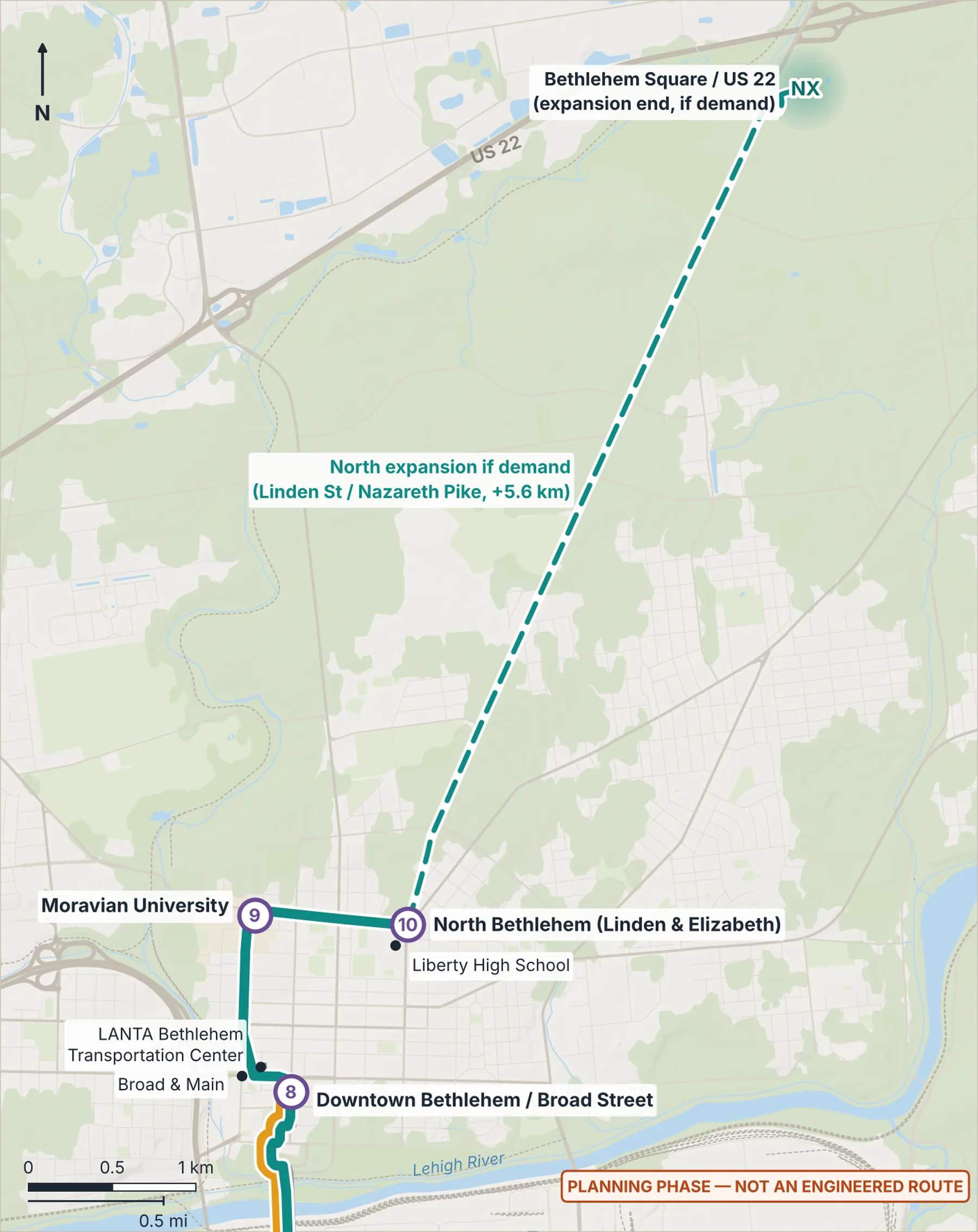
The initial northern end of the Spine, near Liberty High School, with room to extend along the Linden St corridor if demand supports it.
Program ideas Proposed · planning phase
- Terminal charger and layover
- Extra trips at school bell times
Which extras are worth it here, maybe later, or not worth it is rated further down this page.
What exists today Existing today
- About 30 LANTA weekday trips within 400 m (2022 timetable data).
Measured station area
- Elevation
- 103 m (USGS 3DEP)
- 10-minute walk
- 156 ha · 2,002 buildings · 281 places
Walk areas are slope-adjusted 10-minute walksheds on the Overture pedestrian network; building and place counts are intensity proxies, not population or jobs.
Future train access One Connect ride to a rail-ready stop
From North Bethlehem, about 9 minutes on Bethlehem Connect to the rail-ready stop at Farrington Square.
No passenger trains run in Bethlehem today, and no regional rail route or station has been chosen. Rail-ready stops are where this plan would keep space free. How this was measured.
Measured links
- Connect Spine — electric BRT: Moravian University → North Bethlehem · 0.92 km · ~2.4 min · max 5.7%
- North expansion to Bethlehem Square: North Bethlehem → Bethlehem Square / US 22 · 5.62 km · ~11.2 min · max 6.5%
Still unknown
- Terminal and layover site (TBD with the City and LANTA)
Amenities here: worth it or not Screening judgment
Northern terminus near Liberty High School with the largest residential walkshed (2,002 buildings) but light use today (281 places, 30 trips), where the bus layover drives the program (charger, driver relief, drop-off) and the layover site is still to be chosen.
Worth it here
- Secure bike lockers or bike hub, and bike-share docks: A terminus with the largest walkshed (2,002 buildings), so secure lockers extend its reach. Bike share only once an operator exists.
- Drop-off and paratransit loading zone: A terminus by Liberty High School (~2,485 students) draws pick-ups and paratransit; keep it apart from school-bus loading.
- Terminal bus charger (overhead pantograph): Spine buses lay over 5 minutes here, and the plan proposes a terminal pantograph. Site, energy model and grid capacity to confirm.
- Solar panels on the station canopy: Standard canopy solar under the energy plan; no heritage review is identified (to confirm). Shading and crediting to confirm.
- Driver restroom and break room: Drivers lay over here every trip across an 18-hour day, so they need a restroom from day one; use a nearby building.
Maybe later here
- Battery energy storage: Would pair with the terminal charger, but only if demand charges or grid limits make peak trimming pay (values not pulled).
- Equipment-lending lockers or package lockers: 2,002 buildings at a terminus meets the package-locker test, if a vendor installs them free and the layover site has room.
- Energy display with real solar and charging data: Real charger and solar meters are planned here, but only once built and someone maintains the display. Never placeholder data.
Not worth it here
- Heated, enclosed waiting room: Buses every 10 minutes and no infrequent transfers mean about 5-minute waits; a wind-screened shelter, optionally heated, is enough.
- Public restrooms: Below the use test (281 places, 30 trips) with no long waits; driver restrooms are covered separately.
- Staffed customer service: Light use (30 trips) and no intercity links, so the help point and real-time screens are enough.
- Park-and-ride: Walkable neighborhood with no highway interchange; a park-and-ride fits Bethlehem Square only if that extension is built.
- Food or coffee kiosk (partner-run): Below the footfall test (281 places, 30 trips).
- Small shop space: Too few people pass (281 places, 30 trips) to support a tenant.
- Community lounge or study nook: Open-air terminus with no host for a lounge.
- Water bottle filler: No trail, event crowd or long wait here, so a new water line with freeze protection costs more than it gives.
- Event queuing and bus staging space: Liberty High School peaks are handled with extra trips at bell times, not queue corrals.
- Elevators (in pairs), only at level changes: Curbside platform with no level change; ramps handle the rise.
- Ground-source heat pumps (enclosed spaces only): Open-air shelter with nothing enclosed to heat.
- Public art and heritage or geology display: No documented heritage or geology at Linden & Elizabeth in the project files. Built-in art stays optional.
- Snow-melt at the platform edge: Valley stop at 103.0 m on a gentle approach (max 5.7% from Moravian), so the snow and ice plan covers it.
- Regional and intercity bus bays: No regional or intercity carrier stops here.
- Rail-ready space reservation: Not on the protected rail-ready corridor (FARR is 2,931 m away); keeping the Linden St extension open is a bus question.
- Hospital and 24/7 shift-worker features: No 24/7 employer nearby; Liberty High School is a daytime school served by bell-time trips.
- Public Wi-Fi and phone charging: Open-air terminus with about 5-minute waits; real-time screens already meet the need.
Every stop also gets the essentials. Ratings are the author's screening judgment from measured data, not a design or a commitment.