Corridors & Stops
Phase 1 in and around Bethlehem, Hellertown and Fountain Hill; Phase 2 past Bethlehem
Planning phase. An independent plan; nothing is funded or built yet. What this means
The network in brief
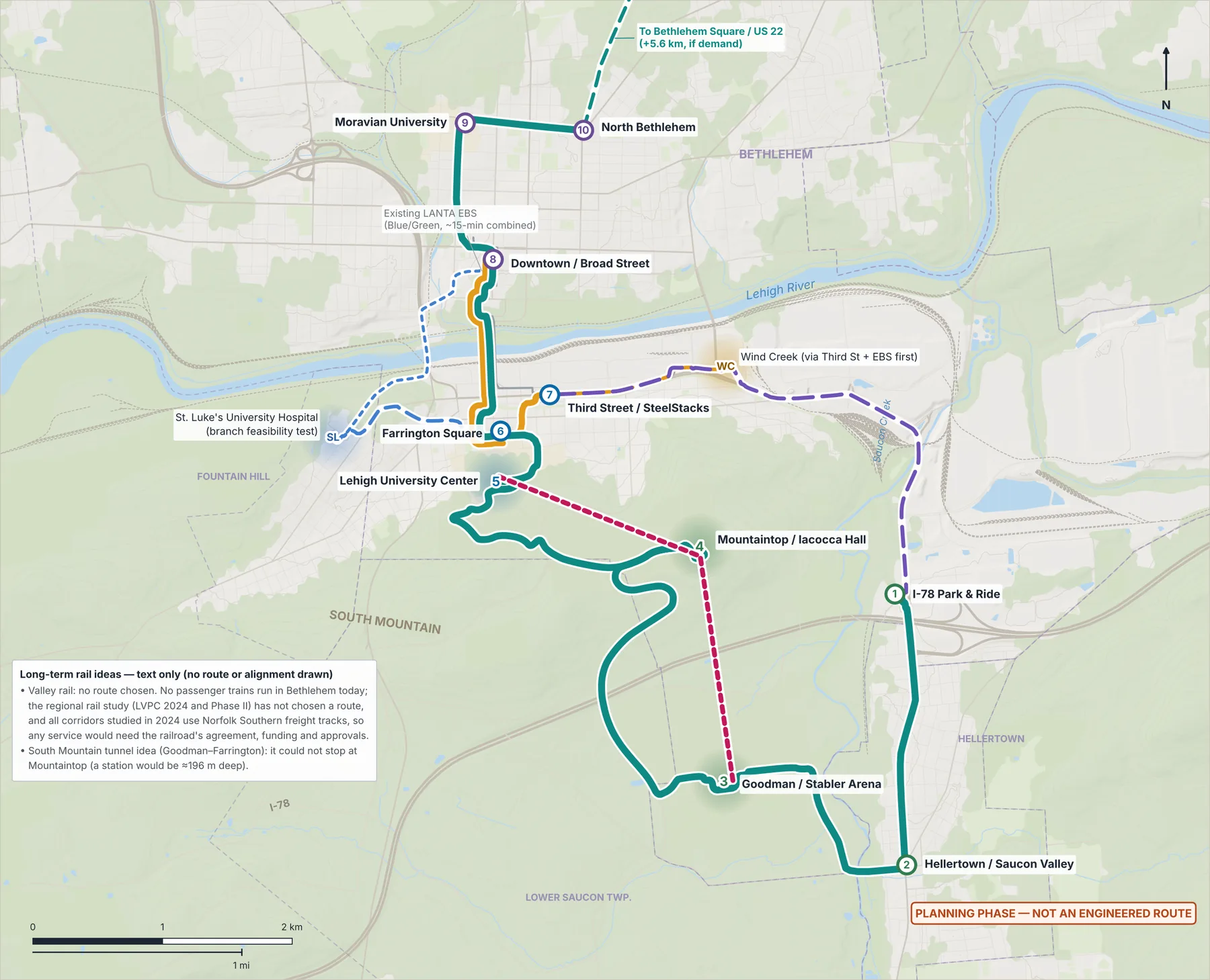
- Phase 1: the Connect Spine, electric bus rapid transit every 10 minutes from the I-78 Park & Ride to North Bethlehem; the River Line, an upgrade of LANTA's EBS core; and the St. Luke's branch from Farrington Square.
- Phase 2: five corridors past Bethlehem and the Airport Link to ABE, only if LANTA agrees. LANTA decides.
- Later, only if demand: the Valley Express, a gondola, extensions to Wind Creek, Bethlehem Square and two township parks, the 4th & Wyandotte and South Bethlehem stops, and express tiers. No target year.
- No passenger trains run in Bethlehem today, and no regional rail route has been chosen.
- Corridor
- Connect Spine · electric BRT
- Status
- Phase 1 · conditional target 2029
- Route (illustrative)
- I-78 P&R → Hellertown Main St → Goodman → Mountaintop / Iacocca Hall (Mountain Dr S) → Lehigh University Center → Farrington → Fahy Bridge → Downtown (Walnut & New) → Broad & Main → Moravian → Linden & Elizabeth
- km
- 16.50
- mi
- 10.3
- min (model)
- 34.6
- Corridor
- River Line · upgraded EBS core
- Status
- Phase 1 · conditional target 2029
- Route (illustrative)
- Downtown → Farrington → Third St / SteelStacks (3rd & Polk)
- km
- 2.51
- mi
- 1.6
- min (model)
- 5.0
- Corridor
- St. Luke's branch · Farrington Square to St. Luke's
- Status
- Phase 1 · conditional target 2029One stop, on Ostrum St
- Route (illustrative)
- Farrington → W 4th St → Ostrum St (St. Luke's University Hospital, Fountain Hill)
- km
- 1.67
- mi
- 1.0
- min (model)
- 3.8
- Corridor
- Airport Link · bus to ABE airport
- Status
- Phase 2 · conditional target 2030Only if LANTA agrees; the terminal stop only if the Airport Authority agrees
- Route (illustrative)
- Downtown (Walnut & New) → W Broad St over the Broad Street Bridge → 8th Ave → Schoenersville Rd (LVH–Muhlenberg) → US 22 → Airport Rd → ABE passenger terminal
- km
- 7.99
- mi
- 5.0
- min (model)
- 13.5
- Corridor
- Valley Express bus
- Status
- Later · only if demand supports itStop for later on the way: South Bethlehem (City parkland), only if a separately proposed park is built
- Route (illustrative)
- I-78 P&R → Rt 412 / Daly Ave → Wind Creek → Third St → Farrington — also the corridor to protect for possible future rail
- km
- 5.15
- mi
- 3.2
- min (model)
- 9.1
- Corridor
- River Line extension to Wind Creek
- Status
- Later · only if demand supports it
- Route (illustrative)
- 3rd & Polk → Daly Ave → Wind Creek Blvd
- km
- 1.46
- mi
- 0.9
- min (model)
- 3.4
- Corridor
- North expansion to Bethlehem Square
- Status
- Later · only if demand supports it
- Route (illustrative)
- Linden & Elizabeth → Linden St corridor → Bethlehem Square / US 22
- km
- 5.62
- mi
- 3.5
- min (model)
- 11.2
- Corridor
- Hanover Township (Northampton County) park extension
- Status
- Later · only if demand supports itAfter the Airport Link (Phase 2) runs
- Route (illustrative)
- LVH–Muhlenberg (Airport Link stop) → Schoenersville Rd → Macada Rd → Jacksonville Rd (Municipal Park main driveway)
- km
- 3.00
- mi
- 1.9
- min (model)
- 6.3
- Corridor
- Bethlehem Township park extension
- Status
- Later · only if demand supports itAfter the North expansion runs
- Route (illustrative)
- Bethlehem Square (end of the North expansion) → Nazareth Pike → Oakland Rd → Easton Ave → Farmersville Rd at Walter Rd (Municipal Park)
- km
- 5.24
- mi
- 3.3
- min (model)
- 10.5
Measured on the existing street network and USGS terrain. Minutes are in-vehicle times from a kinematic model (maximum speed, acceleration, dwell and traffic factors), without waiting or transfers. The gondola (3.42 km, ~12.2 min) is a later idea, not part of Phase 1; see Transportation Alternatives.
Why the mountain matters
Built on what exists
Destinations
South
- I-78 Park & Ride (Hellertown P&R)Southern terminus · regional bus transfers · park-and-ride
- Hellertown / Saucon Valley (Main St)Walk-up town-center stop · Saucon Rail Trail link
- Goodman Campus / Stabler ArenaAthletics, events and fitness
- Mountaintop / Iacocca HallInnovation campus · near a proposed garden · geology space
Lehigh & Southside
North
St. Luke's branch (Phase 1)
Evaluated destinations (later, only if demand)
Not in the plan: a separate Wind Creek station, a second downtown station (Walnut & New pairs with the Bethlehem Transportation Center 236 m away), a Union Station stop, and merging the University Center and Farrington stops.
Phase 2 Airport Link, and what comes later
Airport Link to ABE Phase 2 · conditional target 2030
Two park extensions Later · only if demand supports it
4th & Wyandotte Later · only if demand supports it
South Bethlehem (City parkland)
Later · only if that separate park is built and the Valley Express runs (itself later, only if demand)
A separate park proposal by another project has suggested City parkland in South Bethlehem; its site is not chosen. Connect would add a stop on PA 412 (Hellertown Rd) at Commerce Center Blvd only if a park is built there and riders need one. The City decides about its parkland, the park proposal about its plans, and LANTA and the road owner about any stop.
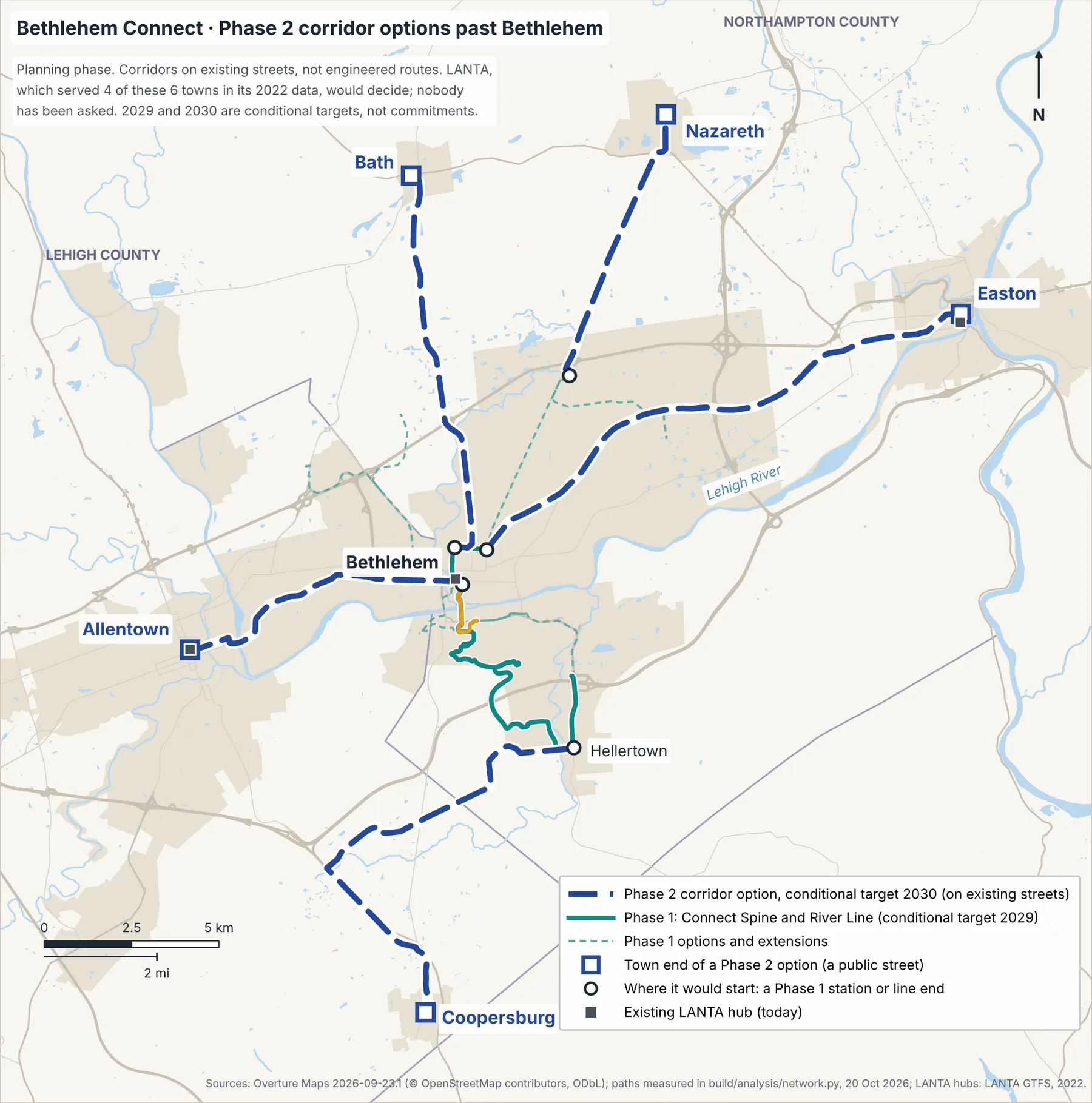
Phase 2 — corridors past Bethlehem
Phase 2 would reach past Bethlehem on existing streets only, with no rail line and no new street. LANTA decides: on streets it already serves, Connect would merge with or feed its routes rather than run beside them (see today's bus routes). Connect would extend past Bethlehem only with owners, regulators and licensed engineers.
What this is not
Today's bus routes on every line
- Where a LANTA route shares a real part of a line, the two would share one timetable and stops there; no route meets the test for replacing it.
- Elsewhere, LANTA routes would feed Connect stations with timed transfers.
- Some Lehigh shuttles could merge only if Lehigh chooses, and Connect would never replace intercity coaches: riders would transfer.
2022 data: check the current routes
The whole network on one page
More detail
Connect Spine, segment by segment
| From | To | km | min | Steepest 100 m |
|---|---|---|---|---|
| I-78 Park & Ride | Hellertown / Saucon Valley | 2.15 | 4.7 | 4.3% |
| Hellertown / Saucon Valley | Goodman / Stabler Arena | 2.13 | 4.6 | 3.2% |
| Goodman / Stabler Arena | Mountaintop / Iacocca Hall | 4.03 | 7.8 | 11.2% |
| Mountaintop / Iacocca Hall | Lehigh University Center | 3.14 | 6.2 | 13.2% |
| Lehigh University Center | Farrington Square | 0.86 | 2.3 | 10.1% |
| Farrington Square | Downtown / Broad Street | 1.83 | 3.3 | 6.3% |
| Downtown / Broad Street | Moravian University | 1.43 | 3.3 | 8.4% |
| Moravian University | North Bethlehem | 0.92 | 2.4 | 5.7% |
Airport Link: route, stops and method
Added 19 October 2026; Phase 2 since the plan's route choice of 22 October 2026 (a proposal, not an approval). Of the PDFs on this website, the Executive Summary, the one-page and two-page summaries and the Long-Term Vision Supplement mention it; the one-page map (v0.8) does not show it.
The Long-Term Vision Supplement names an ultra-express tier between Downtown and Lehigh Valley International Airport (ABE), timed to existing intercity buses. The Airport Link makes that idea concrete enough to measure. Its last 0.3 km is the airport's own access road.
| From | To | km | min | Steepest 100 m |
|---|---|---|---|---|
| Downtown / Broad Street | LVH–Muhlenberg | 4.36 | 8.8 | 7.3% |
| LVH–Muhlenberg | ABE airport terminal | 3.63 | 4.7 | 3.8% |
| Street, in order | km |
|---|---|
| N New St | 0.09 |
| W Broad St, over the Broad Street Bridge | 1.40 |
| 8th Ave | 1.61 |
| Schoenersville Rd | 2.01 |
| US 22 (Lehigh Valley Thruway), with ramps | 2.08 |
| Airport Rd (PA 987) | 0.50 |
| The airport's own access road (airport property) | 0.30 |
A check, not a new route: the same road-class rule, Broad Street Bridge waypoint and run-time assumptions, on a copy of the street network that follows the map data's one-way rules. Every US 22 ramp is one-way, so the return trip stays on Airport Rd and Schoenersville Rd. Its run time uses the highway-bus assumption on a leg with no highway, so it is optimistic. The line's figures stay the measurement above, like every other line's.
- Direction
- Downtown → ABE
- km
- 8.05
- min (model)
- 13.6
- Streets, in order (km)
- N New St 0.09 · W Broad St, over the Broad Street Bridge 1.40 · 8th Ave 1.61 · Schoenersville Rd 2.01 · US 22 (Lehigh Valley Thruway), with ramps 2.08 · Airport Rd (PA 987) 0.49 · City Line Rd 0.02 · The airport's own access road (airport property) 0.35
- Direction
- ABE → Downtown
- km
- 8.55
- min (model)
- 14.2
- Streets, in order (km)
- The airport's own access road (airport property) 0.55 · City Line Rd 0.02 · Airport Rd (PA 987) 1.24 · Unnamed link from Airport Rd to Schoenersville Rd 0.07 · Schoenersville Rd 3.59 · 8th Ave 1.61 · W Broad St, over the Broad Street Bridge 1.40 · N New St 0.09
Stops, and why each one is allowed
- Stop
- 8 · Downtown / Broad Street
- Why it can be a stop
- The proposed station at today's LANTA EBS stop (Walnut & New), shared with the Spine and the River Line.
- What it would need
- Curb space for one more bus route at Walnut & New, to confirm with the City and LANTA.
- Stop
- MH · LVH–Muhlenberg (Schoenersville Rd)
- Why it can be a stop
- A public place: the public street in front of a 24/7 hospital.
- What it would need
- The hospital's views, the municipality's (City of Bethlehem or Hanover Township, Northampton County; boundary to confirm with county parcel data) and the road owner's, a safe crossing and the walk to an entrance (to confirm).
- Stop
- AP · ABE passenger terminal
- Why it can be a stop
- A public place: LANTA's existing stop at the terminal (“LVIA - Airport Transit Center” in LANTA's 2022 data).
- What it would need
- The Airport Authority's agreement, because the stop is on airport property.
How the route was chosen (our judgment)
Separate from the buses that serve ABE today
Passes private sites without a stop
What this is not
Method: shortest street paths on the Overture Maps 2026-09-23.1 drive network (© OpenStreetMap contributors, ODbL) with the road-class rule above; steepest 100 m windows on the USGS 3DEP 1/3″ terrain model, bridge decks interpolated (project analysis, 19 Oct 2026). Terminal stop location: LANTA GTFS feed, June–September 2022. Airport owner: Lehigh-Northampton Airport Authority pages and 2024 annual report (flyabe.com, via a search summary retrieved 19 Oct 2026). The Westgate's private ownership: wfmz.com (retrieved 17 Oct 2026). Trans-Bridge intercity service at ABE: lehighvalleynews.com (Aug 2025, retrieved 18 Oct 2026). LANTA service: lantabus.com (retrieved 18 Oct 2026). One-way rules: Overture Maps access restrictions (same release). Municipal and county boundaries: Overture Maps divisions (same release; to confirm with county parcel data).
Park extensions: measured, the two park stops and checks
Added 19 October 2026 at the author's request; later, only if demand, since 22 October 2026. Not drawn on the PDF maps; the two-page summary (v1.3) lists them.
Each extension runs on existing streets to a stop on the public street at the park's entrance or edge. Neither township, the City of Bethlehem nor LANTA has been asked.
Run times use the city-street bus assumptions (40 km/h top speed, one 25-second stop). Measured without one-way rules, like every other line; the one-way check is in the notes below.
- Extension
- Hanover Township (Northampton County) park extension
- Extends
- Airport Link, from LVH–MuhlenbergPhase 2 · conditional target 2030
- km
- 3.00
- min (model)
- 6.3
- Steepest 100 m
- 3.8%
- Ends at
- Hanover Township (Northampton County) Municipal Park — Jacksonville Rd
- Extension
- Bethlehem Township park extension
- Extends
- North expansion to Bethlehem Square, from Bethlehem Square / US 22Later · only if demand supports it
- km
- 5.24
- min (model)
- 10.5
- Steepest 100 m
- 5.8%
- Ends at
- Bethlehem Township Municipal Park — Farmersville Rd at Walter Rd
Measured on the Overture street network from LVH–Muhlenberg. Street names are simplified.
- Street, in order
- Schoenersville Rd
- km
- 0.40
- Street, in order
- Macada Rd
- km
- 1.11
- Street, in order
- Jacksonville Rd
- km
- 1.49
Measured on the Overture street network from Bethlehem Square / US 22. Street names are simplified.
- Street, in order
- Drive out of Bethlehem Square, where the North expansion ends
- km
- 0.28
- Street, in order
- Unnamed link to Nazareth Pike
- km
- 0.04
- Street, in order
- Nazareth Pike
- km
- 0.66
- Street, in order
- Oakland Rd
- km
- 2.94
- Street, in order
- Easton Ave
- km
- 0.50
- Street, in order
- Farmersville Rd
- km
- 0.83
The two park stops
- Stop
- HT · Hanover Township (Northampton County) Municipal Park and Community Center, 3660 Jacksonville Rd
- Where
- On Jacksonville Rd, a public street, at the park's main driveway opposite Stafore Dr.
- Measured (straight line unless noted)
- 69 m to the park's mapped edge · 262 m to the Community Center (276 m mapped walk) · 392 m to Hanover Elementary School
- What it would need
- Overture maps no footway along Jacksonville Rd within 150 m of the stop (to confirm on site), so a stop would need a safe place to wait and cross. School-time traffic at the school next to the park. The views of the road owner and of Hanover Township (Northampton County).
- Stop
- BT · Bethlehem Township Municipal Park and Community Center, 2900 Farmersville Rd
- Where
- On Farmersville Rd, a public street, at Walter Rd, on the park's west edge.
- Measured (straight line unless noted)
- 3 m to the park's mapped edge · 608 m to the Community Center (811 m mapped walk, along Walter Rd)
- What it would need
- Overture maps a footway along Farmersville Rd within 150 m of the stop (to confirm on site). A stop at the Community Center's door would need Bethlehem Township's agreement: Walter Rd's east leg ends in the center's parking lot, and whether it is a public road is to confirm.
Hanover Township (Northampton County): check the US 22 underpass
Bethlehem Township: start, exit and existing buses
How the routes were chosen (our judgment)
Not costed
Measured: Overture Maps 2026-09-23.1 streets, park areas, places, footways and height limits (© OpenStreetMap contributors, ODbL; places CDLA-Permissive-2.0); USGS 3DEP 1/3″ terrain; LANTA GTFS feed, June–September 2022, service on Wednesday 22 June 2022 (project analysis, 19 Oct 2026). Park and community center addresses: the township websites hanovertwp-nc.org (Municipal Park and Community Center, 3660 Jacksonville Rd) and bethlehemtownship.org (Municipal Park; Community Center, 2900 Farmersville Rd), via search summaries retrieved 19 Oct 2026 (leads, to confirm). Hanover Township in Lehigh County is a different municipality and is not part of this extension.
4th & Wyandotte: spacing check
Added 19 October 2026; later, only if demand, since 22 October 2026. W 4th St and Wyandotte St (PA 378 in the map data) meet on the St. Luke's branch's path between Farrington Square and the hospital, so the branch's own measurement does not change: 1.67 km.
Minimum spacing used here: 400 m from each neighboring stop (our judgment, close to the 1,200–1,400 ft local-stop spacing that NACTO's Transit Street Design Guide suggests; a lead from a search summary retrieved 19 Oct 2026).
- Check
- Distance from Farrington Square, along the branch
- Measured
- 0.73 km
- Result
- Wider than the minimum
- Check
- Distance to St. Luke's (Fountain Hill), along the branch
- Measured
- 0.94 km
- Result
- Wider than the minimum
- Check
- On the branch's own measured path
- Measured
- Yes: both parts add up to the branch
- Result
- The branch's km, minutes and grades are unchanged
- Check
- Branch run time with the stop
- Measured
- ~4.4 min (model)
- Result
- 3.8 min without it
- Check
- LANTA stops within 100 m (2022 data)
- Measured
- 4th at Wyandotte EB (14 m; Route 108) · 4th at Wyandotte WB (18 m; Route 108)
- Result
- Transfer point; current service to confirm
Why later (our judgment)
What it would need
Measured on the Overture Maps 2026-09-23.1 street network (© OpenStreetMap contributors, ODbL), with the same shortest-path rule as the branch; LANTA GTFS feed, June–September 2022 (stops served on Wednesday 22 June 2022). Project analysis, 19 Oct 2026.
South Bethlehem (City parkland) stop: measured
Added 20 October 2026; later, only if demand, since 22 October 2026. Not drawn on the PDF maps; the two-page summary (v1.3) lists it.
Minimum spacing used here: 400 m from each neighboring stop (our judgment, as for 4th & Wyandotte). Run times use the Valley Express's highway-bus assumptions. Mapped walks follow the Overture walking network, which has few mapped paths here, so they are long detours.
- Check
- Distance from I-78 Park & Ride, along the Valley Express
- Measured
- 0.69 km
- What it means
- Wider than the minimum
- Check
- Distance to Wind Creek, along the Valley Express
- Measured
- 2.33 km
- What it means
- Wider than the minimum
- Check
- On the line's own measured path
- Measured
- Yes: both parts add up to the line
- What it means
- The Valley Express's km, minutes and grades are unchanged
- Check
- Run time, I-78 Park & Ride to Wind Creek
- Measured
- ~4.8 min with the stop (model)
- What it means
- 4.0 min without it
- Check
- To the parkland's edge
- Measured
- 210 m straight · 355 m mapped walk
- What it means
- To the nearest mapped street or path in the parkland
- Check
- Without this stop: I-78 Park & Ride (station 1, site unverified) to the parkland's edge
- Measured
- 283 m straight · 556 m mapped walk
- What it means
- The nearest Phase 1 station, and the no-new-stop choice
- Check
- To the South Bethlehem Greenway's mapped south end (Auburn St)
- Measured
- 219 m straight · 626 m mapped walk
- What it means
- The mapped walk is a long detour; a direct path is to check on site
- Check
- To the Saucon Rail Trail's mapped north end (Hellertown)
- Measured
- 1.85 km straight
- What it means
- Overture maps an undeveloped connector trail on an old rail line between them; its mapped north end is 829 m from the stop in a straight line
- Check
- LANTA stops within 400 m (2022 data)
- Measured
- Hellertown and Commerce SB (56 m; Route 105) · Hellertown and Commerce NB (71 m; Routes 105, 215, 605) · Commerce at Gilchrist EB (230 m; Routes 215, 605) · Hellertown at Crest (312 m; Route 105)
- What it means
- Existing service comes first; current routes to confirm
What it would need
Why this intersection (our judgment)
Not costed or flood-checked
Measured: Overture Maps 2026-09-23.1 streets, walking network, park areas, footways and trails (© OpenStreetMap contributors, ODbL); LANTA GTFS feed, June–September 2022 (stops served on Wednesday 22 June 2022); project analysis, 20 Oct 2026.
Phase 2 corridors: measured, street by street, and how they were chosen
LANTA served four of the six town ends (2022 data)
Only where it adds something
In-vehicle minutes in the kinematic model at city-street bus assumptions (40 km/h top speed), between the listed points only: no intermediate stop is chosen, and each one would add about 39 seconds (model). Measured on existing streets in one direction; the one-way check uses the same rule on a copy of the street network that follows the map data's one-way rules. Climb is the total ascent on the USGS terrain model.
- Corridor
- AllentownFrom Downtown / Broad Street to Allentown Transportation Center (N 6th St)
- km
- 8.98
- min (model)
- 17.5
- Climb (m)
- 84
- Steepest 100 m
- 4.8%
- One-way check
- No path against a one-way rule; return trip 9.17 km with one-way rules
- LANTA stops at the town end (2022)
- Allentown: ATC - Platform A (30 m; Routes 100, 101, 211, 213, 218, 220, 319) · ATC - Platform B (75 m; Routes 102, 103, 104, 107, 209, 210, 211, 324)
- Corridor
- EastonFrom North Bethlehem to Easton Centre Square (Northampton St)
- km
- 16.00
- min (model)
- 30.6
- Climb (m)
- 159
- Steepest 100 m
- 8.1%
- One-way check
- No path against a one-way rule; return trip 16.38 km with one-way rules
- LANTA stops at the town end (2022)
- Easton: 3rd at Northampton (80 m; Route 214) · 3rd at Spring Garden (240 m; Route 214) · Easton Intermodal Transportation Center: 249 m from Centre Square (straight line)
- Corridor
- NazarethFrom Bethlehem Square / US 22 to Nazareth borough center (Broad St & Center St)
- km
- 8.37
- min (model)
- 16.4
- Climb (m)
- 102
- Steepest 100 m
- 7.8%
- One-way check
- No path against a one-way rule; return trip 8.38 km with one-way rules
- LANTA stops at the town end (2022)
- Nazareth: Center at Broad WB (30 m; Routes 216, 312) · Center at Main WB (174 m; Routes 216, 312)
- Corridor
- BathFrom Moravian University to Bath borough center (Main St & Northampton St)
- km
- 11.69
- min (model)
- 22.6
- Climb (m)
- 127
- Steepest 100 m
- 8.9%
- One-way check
- 125 m of path against a one-way rule; return trip 11.70 km with one-way rules
- LANTA stops at the town end (2022)
- Bath: none within 400 m; the nearest LANTA stop was 5.1 km away (Routes 216, 312)
- Corridor
- Saucon Valley south and Coopersburg (PA 309)From Hellertown / Saucon Valley to Saucon Valley south (at LANTA's 2022 stops at the corridor's end), then Coopersburg borough center (Main St & State St)
- km
- 14.49
- min (model)
- 28.5
- Climb (m)
- 197
- Steepest 100 m
- 7.9%
- One-way check
- 13 m of path against a one-way rule; return trip 15.16 km with one-way rules
- LANTA stops at the town end (2022)
- Saucon Valley south: LANTA's 2022 stop at the corridor's end, eastbound (24 m; Route 323) · LANTA's 2022 stop at the corridor's end, westbound (89 m; Route 323) · Coopersburg: none within 400 m; the nearest LANTA stop was 5.2 km away (Route 323)
- Corridor
- Allentown corridor
- Route (illustrative)
- Downtown / Broad Street → W Broad St → Hanover Ave → E Hamilton St → Hamilton St → Linden St → Allentown Transportation Center (N 6th St)
- km
- 8.98
- mi
- 5.6
- min (model)
- 17.5
- Corridor
- Easton corridor
- Route (illustrative)
- North Bethlehem → Easton Ave → William Penn Hwy → Butler St → Walnut Ave → Northampton St → Easton Centre Square (Northampton St)
- km
- 16.00
- mi
- 9.9
- min (model)
- 30.6
- Corridor
- Nazareth corridor
- Route (illustrative)
- Bethlehem Square / US 22 → Nazareth Pike → S Broad St (PA 191) → Nazareth borough center (Broad St & Center St)
- km
- 8.37
- mi
- 5.2
- min (model)
- 16.4
- Corridor
- Bath corridor
- Route (illustrative)
- Moravian University → Center St → Bath Pike → Bath borough center (Main St & Northampton St)
- km
- 11.69
- mi
- 7.3
- min (model)
- 22.6
- Corridor
- Saucon Valley south and Coopersburg (PA 309) corridor
- Route (illustrative)
- Hellertown / Saucon Valley → W Water St → Friedensville Rd → Bingen Rd → Saucon Valley Rd → Saucon Valley south (at LANTA's 2022 stops at the corridor's end) → Local streets → PA 309 → Main St → N Main St → Coopersburg borough center (Main St & State St)
- km
- 14.49
- mi
- 9.0
- min (model)
- 28.5
How the routes were chosen (our judgment)
Measured: Overture Maps 2026-09-23.1 streets over a wider area than Phase 1 (© OpenStreetMap contributors, ODbL; build/analysis/extract_phase2.py) and the same USGS 3DEP 1/3″ terrain tile; LANTA GTFS feed, June–September 2022, service on Wednesday 22 June 2022. Project analysis, 20 Oct 2026 (build/analysis/network.py, phase2_corridors). Every Phase 1 number is unchanged by this addition.
Bus routes on every Connect line (LANTA, 2022)
From LANTA's newest feed that could be reached: June-Sept 2022 GTFS (feed_info start 2022-06-20, end 2022-09-06; calendar to 2022-09-11). The newest LANTA feed found on 2026-10-20 is from 2022: LANTA's own GTFS repository was last updated in June 2022, and the Mobility Database lists the same feed as deprecated. A newer feed, if LANTA publishes one, can be dropped in and the screening re-run (build/analysis/bus_overlap.py).
"Along": the share of the line's measured path within 50 m of a LANTA route's 2022 shape. Merge: a route shares at least 1 km and a quarter of the line, so the two would share one timetable and stops there. Feed: a route stops within 400 m of one of the line's stations or stops and brings riders from elsewhere (timed transfers). Replace: most of a route runs where the line would (no route meets that test). Rules: our judgment, a screening, not proposals to LANTA.
- Connect line
- Connect SpinePhase 1 · conditional target 2029
- Along LANTA routes (2022)
- 31% of its 16.50 km
- Merge on shared streets
- Route 105 (Hellertown), 4.2 km
- Feed at stations and stops
- Routes 327, 100, 102, 605, 108, 220, 101, 215, 107, 323, 312, 103
- Lehigh shuttles · intercity buses
- Lehigh: Mountaintop Connector, Goodman Connector, Campus Connector, Packer Express and AccessLU · Transfer: Trans-Bridge at the Bethlehem Transportation Center · Transfer: Greyhound / FlixBus by the Bethlehem Transportation Center · Transfer: Trans-Bridge at the Hellertown Park & Ride (to confirm)
- Connect line
- River LinePhase 1 · conditional target 2029
- Along LANTA routes (2022)
- 66% of its 2.51 km
- Merge on shared streets
- Route 105 (Hellertown), 1.5 km · Route 605 (Bethlehem Circulator), 1.5 km · Route 100 (Green Line), 1.2 km · Route 102 (Union Blvd Local), 1.2 km · Route 108 (Fountain Hill - East Hills), 1.2 km · Route 327 (Fountain Hill - LVIP IV), 1.2 km
- Feed at stations and stops
- Routes 323, 103, 101, 107, 215, 220, 312
- Lehigh shuttles · intercity buses
- Transfer: Trans-Bridge at the Bethlehem Transportation Center · Transfer: Greyhound / FlixBus by the Bethlehem Transportation Center
- Connect line
- St. Luke's branchPhase 1 · conditional target 2029
- Along LANTA routes (2022)
- 80% of its 1.67 km
- Merge on shared streets
- Route 108 (Fountain Hill - East Hills), 1.3 km
- Feed at stations and stops
- Routes 327, 103, 323, 100, 102, 105, 605
- Lehigh shuttles · intercity buses
- None
- Connect line
- Valley ExpressLater · only if demand supports it
- Along LANTA routes (2022)
- 89% of its 5.15 km
- Merge on shared streets
- Route 105 (Hellertown), 2.7 km · Route 215 (Schoenersville), 2.4 km · Route 605 (Bethlehem Circulator), 2.1 km · Route 100 (Green Line), 1.7 km · Route 102 (Union Blvd Local), 1.7 km
- Feed at stations and stops
- Routes 103, 323, 108, 327
- Lehigh shuttles · intercity buses
- Transfer: Trans-Bridge at Wind Creek · Transfer: Trans-Bridge at the Hellertown Park & Ride (to confirm)
- Connect line
- Wind Creek extensionLater · only if demand supports it
- Along LANTA routes (2022)
- 100% of its 1.46 km
- Merge on shared streets
- Route 100 (Green Line), 1.5 km · Route 102 (Union Blvd Local), 1.5 km
- Feed at stations and stops
- Routes 323, 215, 103, 105, 605
- Lehigh shuttles · intercity buses
- Transfer: Trans-Bridge at Wind Creek
- Connect line
- North expansion to Bethlehem SquareLater · only if demand supports it
- Along LANTA routes (2022)
- 31% of its 5.62 km
- Merge on shared streets
- Route 108 (Fountain Hill - East Hills), 1.6 km
- Feed at stations and stops
- Routes 319, 327, 220
- Lehigh shuttles · intercity buses
- None
- Connect line
- Hanover Township (Northampton County) park extensionLater · only if demand supports it
- Along LANTA routes (2022)
- 7% of its 3.00 km
- Merge on shared streets
- None
- Feed at stations and stops
- Routes 215, 105
- Lehigh shuttles · intercity buses
- None
- Connect line
- Bethlehem Township park extensionLater · only if demand supports it
- Along LANTA routes (2022)
- 45% of its 5.24 km
- Merge on shared streets
- Route 220 (Bethlehem - Easton), 1.3 km · Route 312 (Bethlehem - NCC - Nazareth), 1.3 km
- Feed at stations and stops
- Routes 108, 319, 327
- Lehigh shuttles · intercity buses
- None
- Connect line
- Airport LinkPhase 2 · conditional target 2030
- Along LANTA routes (2022)
- 70% of its 7.99 km
- Merge on shared streets
- Route 215 (Schoenersville), 4.8 km · Route 105 (Hellertown), 3.8 km
- Feed at stations and stops
- Routes 101, 220, 100, 102, 107, 324, 319, 108, 327, 605, 312
- Lehigh shuttles · intercity buses
- Transfer: Trans-Bridge at the Bethlehem Transportation Center · Transfer: Greyhound / FlixBus by the Bethlehem Transportation Center · Transfer: Trans-Bridge at the ABE terminal
- Connect line
- Allentown corridorPhase 2 · conditional target 2030
- Along LANTA routes (2022)
- 95% of its 8.98 km
- Merge on shared streets
- Route 220 (Bethlehem - Easton), 8.1 km · Route 107 (Hanover Ave), 8.0 km · Route 102 (Union Blvd Local), 3.0 km · Route 101 (Blue Line), 3.0 km · Route 100 (Green Line), 2.9 km · Route 324 (Airport), 2.6 km
- Feed at stations and stops
- Routes 215, 210, 103, 105, 108, 327, 605, 209, 211, 312, 104, 319, 213, 218
- Lehigh shuttles · intercity buses
- Transfer: Trans-Bridge at the Bethlehem Transportation Center · Transfer: Greyhound / FlixBus by the Bethlehem Transportation Center
- Connect line
- Easton corridorPhase 2 · conditional target 2030
- Along LANTA routes (2022)
- 100% of its 16.00 km
- Merge on shared streets
- Route 101 (Blue Line), 10.8 km · Route 220 (Bethlehem - Easton), 10.4 km
- Feed at stations and stops
- Routes 106, 216, 214, 606
- Lehigh shuttles · intercity buses
- Transfer: Local and intercity buses at the Easton Intermodal Transportation Center
- Connect line
- Nazareth corridorPhase 2 · conditional target 2030
- Along LANTA routes (2022)
- 76% of its 8.37 km
- Merge on shared streets
- Route 312 (Bethlehem - NCC - Nazareth), 5.7 km
- Feed at stations and stops
- Routes 216, 319, 327, 108
- Lehigh shuttles · intercity buses
- None
- Connect line
- Bath corridorPhase 2 · conditional target 2030
- Along LANTA routes (2022)
- 40% of its 11.69 km
- Merge on shared streets
- Route 327 (Fountain Hill - LVIP IV), 4.7 km
- Feed at stations and stops
- Routes 220
- Lehigh shuttles · intercity buses
- None
- Connect line
- Saucon Valley south and Coopersburg (PA 309) corridorPhase 2 · conditional target 2030
- Along LANTA routes (2022)
- 17% of its 14.49 km
- Merge on shared streets
- None
- Feed at stations and stops
- Routes 323, 105
- Lehigh shuttles · intercity buses
- None
Feed: LANTA (Lehigh and Northampton Transportation Authority), June-Sept 2022 GTFS (feed_info start 2022-06-20, end 2022-09-06; calendar to 2022-09-11); looked for on 2026-10-20 in LANTA's own GTFS repository, github.com/LANTA-Transportation-Authority/GTFS-data: newest commit d10a6a0, 21 Jun 2022 ('June 2022 updates'); its lanta_gtfs_feed.zip is byte-identical to the feed used here; Mobility Database catalog entry 506 (mobility-database-catalogs, catalog as of 19 Oct 2026): status 'deprecated'; its latest stored copy is the same 2022 feed; Transitland, files.mobilitydatabase.org and lantabus.com could not be reached from this workspace (proxy refusal), so a newer feed, if one exists, was not found. Method: build/analysis/bus_overlap.py.
Lehigh shuttles and intercity buses at Connect places
Lehigh runs its shuttles and decides their future. Lehigh has agreed to nothing, and the plan's records show no request to Lehigh about merging or reducing shuttles. Fewer separate routes would not mean fewer buses on the hill: a 10-minute Spine would run about as many trips as Lehigh does today, or more (an estimate from schedule leads). The gondola (later idea): No street path, so no LANTA route runs along it; Lehigh's Mountaintop Connector serves the same University Center to Mountaintop / Iacocca Hall trip (lead). Source: auxiliaryservices.lehigh.edu/transit-route-information (and its route pages), search summaries retrieved 19 Oct 2026.
- Shuttle
- Mountaintop Connector
- What it does (leads)
- Weekdays, Asa Packer campus to Mountaintop (stops include Iacocca Hall and Whitaker Lab), two buses, Fall 2025 schedule repeated for Spring 2026
- With Connect
- merge only if Lehigh choosesRuns the Spine's University Center to Mountaintop / Iacocca Hall trip on Lehigh's campus roads
- Shuttle
- Goodman Connector
- What it does (leads)
- Weekdays, Goodman campus to Asa Packer (stops include Goodman Circle, Whitaker Lab and Farrington Square), one bus, Spring 2026; its road path is not known
- With Connect
- merge only if Lehigh choosesServes the same Goodman, Asa Packer and Farrington Square places as the Spine; the paths may differ
- Shuttle
- Campus Connector
- What it does (leads)
- Evenings and weekends, Asa Packer, Mountaintop and Goodman campuses and Saucon Village (Spring 2026)
- With Connect
- merge only if Lehigh choosesCovers the Spine's three campus stations when the weekday connectors do not run
- Shuttle
- Packer Express
- What it does (leads)
- Loop inside the Asa Packer campus only, weekdays in the fall and spring semesters (Spring 2026)
- With Connect
- transferConnect does not duplicate it; riders would change at the Lehigh University Center or Farrington Square
- Shuttle
- AccessLU
- What it does (leads)
- Lehigh's on-demand accessible service
- With Connect
- keep (not duplicated)An on-demand accessible service would still be needed with any fixed line
Connect would never replace intercity coaches: riders would simply transfer. Every row is a lead from the project's research (search summaries and operator pages, retrieved 17–19 Oct 2026); current stops and times are to confirm with each operator.
- Operator
- Trans-Bridge Lines
- Where
- Bethlehem Transportation Center (Broad St), by the Downtown / Broad Street station areaAllentown/Clinton/New York route (schedule effective 25 Jul 2025; a run added 10 Jul 2026)
- Connect lines
- Connect Spine, River Line, Airport Link, Allentown corridor
- Operator
- Greyhound / FlixBus
- Where
- 635 Guetter St, by the Bethlehem Transportation CenterStop listed for Greyhound and FlixBus schedules
- Connect lines
- Connect Spine, River Line, Airport Link, Allentown corridor
- Operator
- Trans-Bridge Lines
- Where
- Wind Creek BethlehemWind Creek schedule effective 8 Jun 2026: Trans-Bridge intercity coaches between New York's Port Authority Bus Terminal and Wind Creek, with stops on the way
- Connect lines
- Valley Express, Wind Creek extension
- Operator
- Trans-Bridge Lines
- Where
- ABE airport passenger terminalTrans-Bridge intercity coaches leave from ABE (reservation-only, since 8 Sep 2025)
- Connect lines
- Airport Link
- Operator
- Trans-Bridge Lines
- Where
- Hellertown Park & Ride (Silvex Rd near I-78 Exit 67)Listed on Allentown/Clinton westbound timetables of Sep and Oct 2025; which runs stop there today is to confirm, and so is whether it is the lot Connect's I-78 Park & Ride would use
- Connect lines
- Connect Spine, Valley Express
- Operator
- LANTA, NJ Transit, Greyhound, Trans-Bridge and Fullington Trailways
- Where
- Easton Intermodal Transportation Center (opened 2015)Reported to serve these operators' local and intercity buses
- Connect lines
- Easton corridor
Hospitals and health campuses
Hospitals run around the clock, so staff, patients and visitors need early, late and weekend service. Naming a hospital here implies no partnership: no hospital has been asked or has agreed to anything.
St. Luke’s University Hospital – Bethlehem
St. Luke’s University Health Network (main campus; adult Level I trauma center) · 801 Ostrum St · Fountain Hill Borough
Phase 1 · St. Luke's branch stopThe St. Luke's branch: 1.67 km from Farrington Square via W 4th St to one stop on Ostrum St, about 3.8 min (model).
Today: LANTA Route 108, seven days a week; some evening trips were cut in June 2026.
Future train access: About 4 minutes by bus from the rail-ready stop at Farrington Square.
Lehigh Valley Hospital–Muhlenberg
Lehigh Valley Health Network, part of Jefferson Health (adult Level II trauma center) · 2545 Schoenersville Rd · City of Bethlehem, north of US 22
Phase 2 · Airport Link stopNot in Phase 1. The Airport Link (Phase 2, only if LANTA agrees) would stop on Schoenersville Rd at the hospital's middle driveway: 4.36 km from Downtown (model; the walk to an entrance is to confirm).
Today: LANTA Routes 105 and 324 list a hospital stop; some evening trips were cut in June 2026.
Future train access: Today, none. With the Airport Link (Phase 2): about 8.8 min from Downtown (model, measured outbound); Downtown is 3.3 min from the rail-ready stop at Farrington Square.
St. Luke’s Hospital – Anderson Campus
St. Luke’s University Health Network (Heart Hospital opened 2 Oct 2026) · 1872 St. Luke’s Blvd · Bethlehem Township (Easton mailing address)
Not in the plan7–9 km from the nearest Phase 1 stop. LANTA remains the connection; the Phase 2 Easton corridor does not pass the campus.
Today: LANTA Route 312 on weekdays (weekend service to confirm).
Future train access: Long-term only.
- Hospital
- St. Luke’s University Hospital – BethlehemSt. Luke’s University Health Network (main campus; adult Level I trauma center)801 Ostrum St · Fountain Hill Borough
- Today (LANTA)
- LANTA Route 108, seven days a week; some evening trips were cut in June 2026.
- In this plan
- Phase 1 · St. Luke's branch stopThe St. Luke's branch: 1.67 km from Farrington Square via W 4th St to one stop on Ostrum St, about 3.8 min (model).
- Future train access
- About 4 minutes by bus from the rail-ready stop at Farrington Square.
- Hospital
- Lehigh Valley Hospital–MuhlenbergLehigh Valley Health Network, part of Jefferson Health (adult Level II trauma center)2545 Schoenersville Rd · City of Bethlehem, north of US 22
- Today (LANTA)
- LANTA Routes 105 and 324 list a hospital stop; some evening trips were cut in June 2026.
- In this plan
- Phase 2 · Airport Link stopNot in Phase 1. The Airport Link (Phase 2, only if LANTA agrees) would stop on Schoenersville Rd at the hospital's middle driveway: 4.36 km from Downtown (model; the walk to an entrance is to confirm).
- Future train access
- Today, none. With the Airport Link (Phase 2): about 8.8 min from Downtown (model, measured outbound); Downtown is 3.3 min from the rail-ready stop at Farrington Square.
- Hospital
- St. Luke’s Hospital – Anderson CampusSt. Luke’s University Health Network (Heart Hospital opened 2 Oct 2026)1872 St. Luke’s Blvd · Bethlehem Township (Easton mailing address)
- Today (LANTA)
- LANTA Route 312 on weekdays (weekend service to confirm).
- In this plan
- Not in the plan7–9 km from the nearest Phase 1 stop. LANTA remains the connection; the Phase 2 Easton corridor does not pass the campus.
- Future train access
- Long-term only.
What hospital stops would need
Names and service change
Sources (retrieved 18 Oct 2026): slhn.org (St. Luke's Bethlehem and Anderson campus pages; Heart Hospital opening, 2 Oct 2026); lvhn.org (LVH–Muhlenberg location and Level II trauma pages); lehighvalleynews.com (Jefferson–LVHN combination, 1 Aug 2024); lantabus.com (Routes 105, 108, 312 and 324; June 2026 service changes). Distances: Overture Maps pedestrian and street networks (project analysis). Municipalities are to confirm with county parcel data.