Station area 1 · South
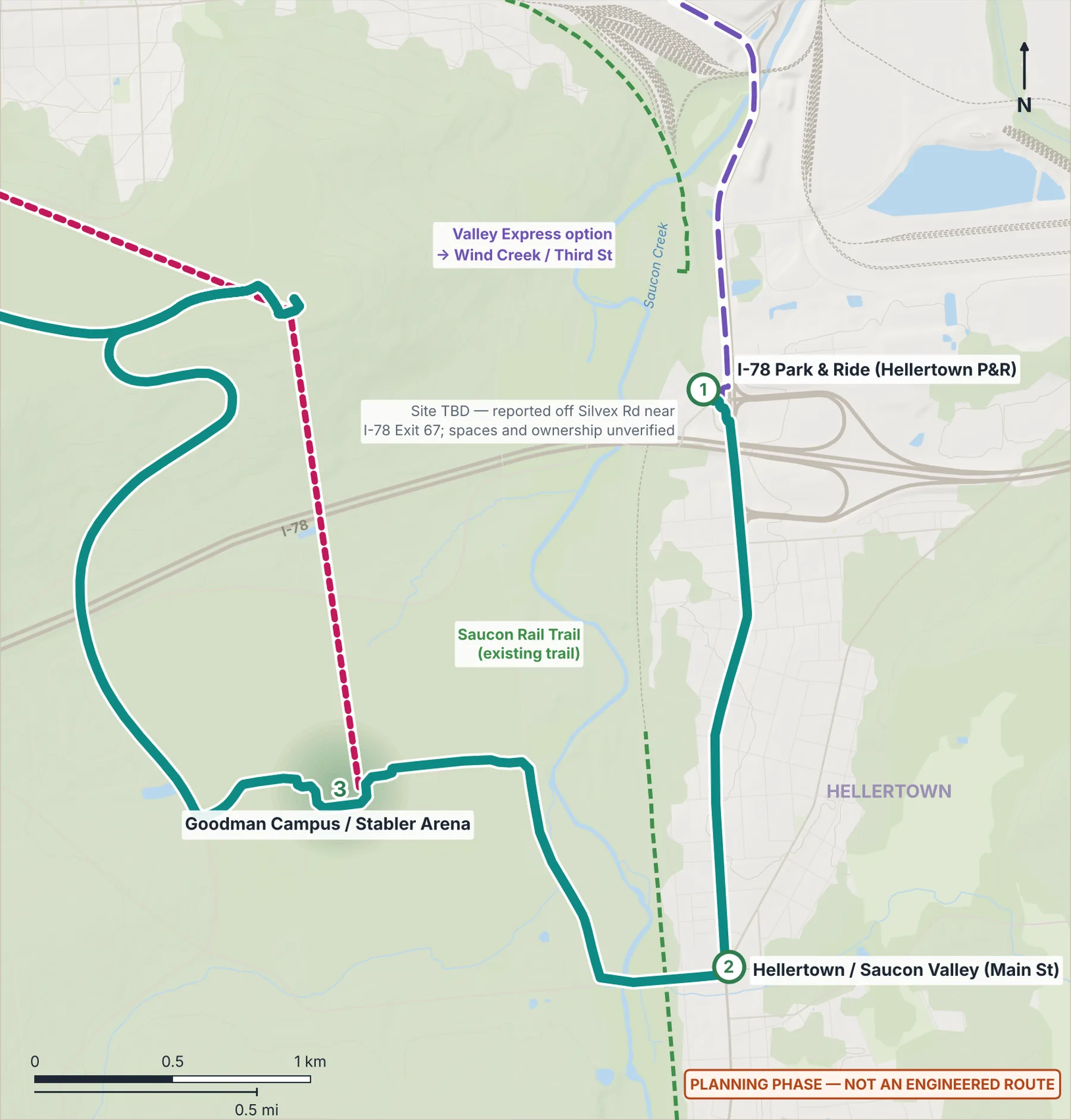
I-78 Park & Ride (Hellertown P&R)
Planning phase. An independent plan; nothing is funded or built yet. What this means
Why here
A southern endpoint where students, workers, visitors and event traffic can switch from car or regional bus to frequent electric service, instead of driving into the city.
Program ideas Proposed · planning phase
- Regional and intercity bus bays
- Park-and-ride
- Solar carport (option ≈1 MWdc)
- Terminal charger with battery to trim peaks
- Bike lockers
Which extras are worth it here, maybe later, or not worth it is rated further down this page.
What exists today Existing today
- A park-and-ride is reported behind Turkey Hill off Silvex Rd near I-78 Exit 67; site, spaces and ownership are unverified.
Measured station area
- Elevation
- 84 m (USGS 3DEP)
Future train access On the rail-ready corridor
Sits on the rail-ready valley corridor at I-78 Park & Ride.
No passenger trains run in Bethlehem today, and no regional rail route or station has been chosen. Rail-ready stops are where this plan would keep space free. How this was measured.
Measured links
- Connect Spine — electric BRT: I-78 Park & Ride → Hellertown / Saucon Valley · 2.15 km · ~4.7 min · max 4.3%
- Valley Express — bus option: I-78 Park & Ride → Wind Creek · 3.02 km · ~4.0 min · max 6.5%
Stop options on the way
- South Bethlehem (City parkland)An optional stop on the Valley Express, 0.69 km from here, only if a separately proposed park is built. It was added after this page’s map, so the map does not show it.
Still unknown
- Exact site, number of spaces and ownership (PennDOT P&R records, LANTA)
- Saucon Creek flooding is separate from the river and needs checking
Amenities here: worth it or not Screening judgment
Southern terminus and park-and-ride at a reported lot off Silvex Rd near I-78 Exit 67 (site, spaces and owner to confirm), where terminus needs drive the program and all equipment must sit above the Saucon Creek flood level (to check).
Worth it here
- Secure bike lockers or bike hub, and bike-share docks: A terminus and park-and-ride where the plan proposes bike lockers. No bike-share docks until an operator exists.
- Park-and-ride: Network edge at I-78 with a thin walkshed. Share the reported lot by agreement instead of building spaces (site, owner to confirm).
- Drop-off and paratransit loading zone: Riders arrive by car at the terminus; a cheap accessible drop-off and paratransit bay can sit off the bus platform.
- Terminal bus charger (overhead pantograph): South terminus with 5-minute layovers on an 89.6-minute cycle. Energy model, grid capacity and Saucon Creek flood siting to confirm.
- Solar panels on the station canopy: Open site with no known heritage limit. Counts as yearly energy equivalence, not direct bus power; carport waits on lot ownership.
- Driver restroom and break room: South terminus with 5-minute layovers over an 18-hour day. Use an existing building by agreement, above flood level (to confirm).
- Rail-ready space reservation: On the protected rail-ready corridor: keep room for a 60-90 m platform and a clear future trackway. Low-cost reservation only.
Maybe later here
- Heated, enclosed waiting room: Valley site with 10-minute service, so waits are short. Add a room only if intercity bays bring long waits (carriers to confirm).
- Public restrooms: Low use near the proxy point (55 places, 18 trips). Revisit if intercity bays come; check the reported Turkey Hill store first.
- Battery energy storage: Could trim terminal charger peaks, but only if demand charges (not yet pulled) justify it. Site above Saucon Creek flood level.
- Equipment-lending lockers or package lockers: No venue for lending lockers, but package lockers could suit a P&R terminus if a vendor installs them free (to confirm).
- Water bottle filler: Only if intercity bays bring long waits and a water line already reaches an on-site building (to confirm).
- Regional and intercity bus bays: LANTA Route 105 already serves a Hellertown P&R stop, but no intercity carrier has agreed. Reserve space; build only with agreement.
- Energy display with real solar and charging data: Likeliest site for real charger and solar data, but only once those systems exist and a host maintains the screen.
- Public Wi-Fi and phone charging: Only if PNR gets an enclosed waiting room, which depends on intercity bays (to confirm).
Not worth it here
- Staffed customer service: Only 18 LANTA trips near the proxy point, so the help point and real-time screens are enough.
- Food or coffee kiosk (partner-run): Footfall near the proxy point (55 places, 18 trips) is far below 500/200. Point riders to the reported Turkey Hill store.
- Small shop space: Low footfall and no existing ground floor facing the platform. New standalone retail is never worth it.
- Community lounge or study nook: A park-and-ride terminus with no host partner is the wrong place for a lounge.
- Event queuing and bus staging space: No large venue nearby. Event parking would use the reported lot by owner agreement, with no corrals built.
- Elevators (in pairs), only at level changes: Curbside platform with no level change; ramps handle the 0.36 m rise.
- Ground-source heat pumps (enclosed spaces only): No enclosed space is planned, and the valley's carbonate ground would need karst screening.
- Public art and heritage or geology display: No documented heritage or geology at the site in the project files. Art built into windscreens or paving stays optional.
- Snow-melt at the platform edge: Valley site at 83.7 m on gentle grades (max 4.3% to Hellertown), so the snow and ice plan covers it.
- Hospital and 24/7 shift-worker features: No 24/7 employer with about 2,000 staff within 400 m in the project files.
Every stop also gets the essentials. Ratings are the author's screening judgment from measured data, not a design or a commitment.