One-page summary
Bethlehem Connect
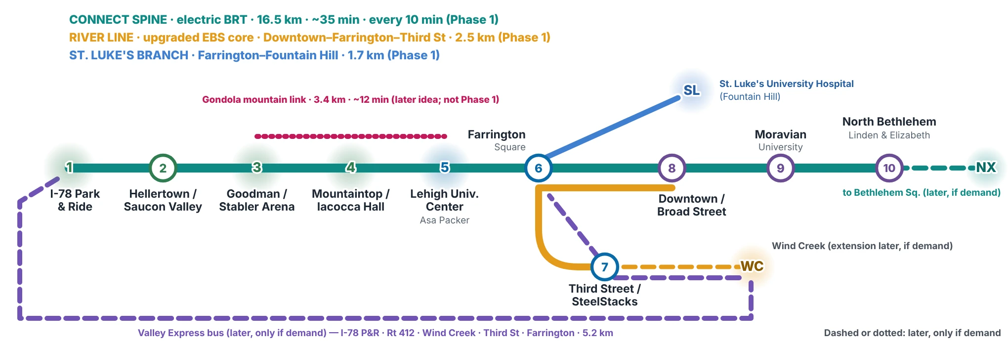
A hybrid, high-frequency electric transit plan linking Saucon Valley, Lehigh's three campuses, the Southside, Downtown, Moravian University and North Bethlehem, built on today's bus service.
 (opens the full-size image)
The idea in brief
- Terrain decides the mode. Mountaintop (≈275 m) sits about 180 m above Goodman and 153 m above the University Center; campus roads reach 11–13% grades. Buses can serve it today, a gondola fits the slope best, and surface rail does not fit.
- Build on LANTA's Enhanced Bus Service. EBS already runs about every 15 minutes Downtown – Fahy Bridge – Southside. Phase 1 extends and electrifies it rather than duplicating it.
- Serve everyone, not just Lehigh. Residents of Hellertown, the Southside and North Bethlehem; students at Lehigh, Moravian and Liberty High School; workers at St. Luke's, Wind Creek and Lehigh; visitors to SteelStacks and Stabler; regional travelers through the I-78 Park & Ride.
What we are asking for
- LVPC: how a plan like this could be considered in the FutureLV process.
- LANTA: fit with EBS; boardings, GTFS and park-and-ride data.
- Lehigh University: the mountain link (bus or gondola), the Mountaintop and Goodman station areas, shuttle data.
- City of Bethlehem: fit with the draft Complete Streets Plan, the Broad and Linden St projects and the planned South Side Community Center.
Proposed phases (indicative)
| P0 now – mid-2027 | Conversations and data with LVPC, LANTA, Lehigh and the City; align with the FutureLV long-range plan update |
|---|---|
| Phase 1 target 2029 | In and around Bethlehem and Hellertown: Connect Spine and River Line, one brand and fare with LANTA and campus shuttles if they agree; options (Valley Express, St. Luke's, Airport Link to ABE, gondola after studies) and extensions if demand |
| Phase 2 target 2030 | Corridor options past Bethlehem to Allentown, Easton, Nazareth, Bath, Saucon Valley south and Coopersburg, on existing streets, only if LANTA agrees |
| Later after 2030 | Full bus lanes where data support them; express tiers only if measured triggers are met; electric rail or subway only if ridership, funding and engineering gates are met |
2029 and 2030 are conditional targets, not commitments: they depend on a sponsor adopting the route, funding and operating partners.
Bethlehem 2030 path (conditional targets): a River Line pilot in 2028 on leased battery-electric buses, Phase 1 by 2029 and Phase 2 by 2030, only if a sponsor, funding and approvals come first, mostly in 2027. Comparable projects often slipped 1–2 years.
Questions to answer first
- Who could fund about 71,000 new service hours a year, and in what shares?
- Can battery buses run all winter on 11–13% grades, and at what energy use?
- Gondola: South Mountain wind data, the Pennsylvania regulatory path, evacuation, Lehigh land and forest impacts.
A one-page visual for each place (14: the Spine, every station area and each evaluated destination) is under “Each place” on website-five-tau-72.vercel.app/. The full Executive Summary: website-five-tau-72.vercel.app/files/executive-summary.pdf.